You are here: Home > Network List > TA - USArray Transportable Network (new EarthScope stations) Stations List
> Station U19A Dine' College, Tsaile, AZ, USA > Earthquake Result Viewer
U19A Dine' College, Tsaile, AZ, USA - Earthquake Result Viewer
| Earthquake location: |
Fiji Islands Region |
| Earthquake latitude/longitude: |
-17.3/-177.3 |
| Earthquake time(UTC): |
2008/07/19 (201) 22:39:52 GMT |
| Earthquake Depth: |
391 km |
| Earthquake Magnitude: |
5.9 MB, 6.4 MW, 6.4 MW |
| Earthquake Catalog/Contributor: |
WHDF/NEIC |
|
| Network: |
TA USArray Transportable Network (new EarthScope stations) |
| Station: |
U19A Dine' College, Tsaile, AZ, USA |
| Lat/Lon: |
36.29 N/109.21 W |
| Elevation: |
2166 m |
|
| Distance: |
83.5 deg |
| Az: |
48.979 deg |
| Baz: |
243.122 deg |
| Ray Param: |
0.045096397 |
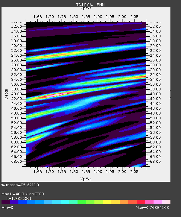
| Estimated Moho Depth: |
40.0 km |
| Estimated Crust Vp/Vs: |
1.74 |
| Assumed Crust Vp: |
6.476 km/s |
| Estimated Crust Vs: |
3.727 km/s |
| Estimated Crust Poisson's Ratio: |
0.25 |
|
| Radial Match: |
85.62113 % |
| Radial Bump: |
400 |
| Transverse Match: |
77.454056 % |
| Transverse Bump: |
400 |
| SOD ConfigId: |
2504 |
| Insert Time: |
2010-03-06 14:40:38.767 +0000 |
| GWidth: |
2.5 |
| Max Bumps: |
400 |
| Tol: |
0.001 |
|

Signal To Noise
| Channel | StoN | STA | LTA |
| TA:U19A: :BHN:20080719T22:51:06.600024Z | 30.858725 | 2.2102577E-6 | 7.162505E-8 |
| TA:U19A: :BHE:20080719T22:51:06.600024Z | 2.227609 | 3.2747676E-7 | 1.470082E-7 |
| TA:U19A: :BHZ:20080719T22:51:06.600024Z | 6.1375446 | 9.269094E-7 | 1.5102285E-7 |
| Arrivals |
| Ps | 4.7 SECOND |
| PpPs | 16 SECOND |
| PsPs/PpSs | 21 SECOND |


