You are here: Home > Network List > TA - USArray Transportable Network (new EarthScope stations) Stations List
> Station U19A Dine' College, Tsaile, AZ, USA > Earthquake Result Viewer
U19A Dine' College, Tsaile, AZ, USA - Earthquake Result Viewer

| Earthquake location: |
Kuril Islands |
| Earthquake latitude/longitude: |
51.0/157.6 |
| Earthquake time(UTC): |
2008/07/24 (206) 01:43:16 GMT |
| Earthquake Depth: |
27 km |
| Earthquake Magnitude: |
6.0 MB, 6.0 MS, 6.2 MW, 6.2 MW |
| Earthquake Catalog/Contributor: |
WHDF/NEIC |
|
| Network: |
TA USArray Transportable Network (new EarthScope stations) |
| Station: |
U19A Dine' College, Tsaile, AZ, USA |
| Lat/Lon: |
36.29 N/109.21 W |
| Elevation: |
2166 m |
|
| Distance: |
64.7 deg |
| Az: |
63.188 deg |
| Baz: |
315.691 deg |
| Ray Param: |
0.05874106 |
| Estimated Moho Depth: |
57.5 km |
| Estimated Crust Vp/Vs: |
1.72 |
| Assumed Crust Vp: |
6.476 km/s |
| Estimated Crust Vs: |
3.771 km/s |
| Estimated Crust Poisson's Ratio: |
0.24 |
|
| Radial Match: |
87.63864 % |
| Radial Bump: |
400 |
| Transverse Match: |
83.2988 % |
| Transverse Bump: |
400 |
| SOD ConfigId: |
2504 |
| Insert Time: |
2010-03-06 14:40:41.403 +0000 |
| GWidth: |
2.5 |
| Max Bumps: |
400 |
| Tol: |
0.001 |
|
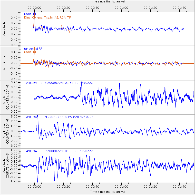
Signal To Noise
| Channel | StoN | STA | LTA |
| TA:U19A: :BHN:20080724T01:53:20.475022Z | 14.02174 | 1.242563E-6 | 8.861689E-8 |
| TA:U19A: :BHE:20080724T01:53:20.475022Z | 5.1594477 | 4.6780738E-7 | 9.067004E-8 |
| TA:U19A: :BHZ:20080724T01:53:20.475022Z | 6.1087403 | 3.851837E-7 | 6.305453E-8 |
| Arrivals |
| Ps | 6.7 SECOND |
| PpPs | 23 SECOND |
| PsPs/PpSs | 30 SECOND |


