You are here: Home > Network List > TA - USArray Transportable Network (new EarthScope stations) Stations List
> Station G31M Satah River, YT, CAN > Earthquake Result Viewer
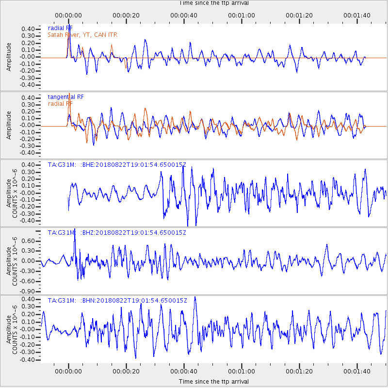
G31M Satah River, YT, CAN - Earthquake Result Viewer
*The percent match for this event was below the threshold and hence no stack was calculated.
| Earthquake location: |
Solomon Islands |
| Earthquake latitude/longitude: |
-7.0/155.7 |
| Earthquake time(UTC): |
2018/08/22 (234) 18:49:36 GMT |
| Earthquake Depth: |
34 km |
| Earthquake Magnitude: |
5.8 Mww |
| Earthquake Catalog/Contributor: |
NEIC PDE/us |
|
| Network: |
TA USArray Transportable Network (new EarthScope stations) |
| Station: |
G31M Satah River, YT, CAN |
| Lat/Lon: |
66.92 N/134.27 W |
| Elevation: |
61 m |
|
| Distance: |
88.7 deg |
| Az: |
21.749 deg |
| Baz: |
248.931 deg |
| Ray Param: |
$rayparam |
*The percent match for this event was below the threshold and hence was not used in the summary stack. |
|
| Radial Match: |
60.457047 % |
| Radial Bump: |
400 |
| Transverse Match: |
52.36491 % |
| Transverse Bump: |
400 |
| SOD ConfigId: |
13570011 |
| Insert Time: |
2019-04-30 23:16:21.435 +0000 |
| GWidth: |
2.5 |
| Max Bumps: |
400 |
| Tol: |
0.001 |
|
Signal To Noise
| Channel | StoN | STA | LTA |
| TA:G31M: :BHZ:20180822T19:01:54.650015Z | 3.6915429 | 3.0999274E-7 | 8.397376E-8 |
| TA:G31M: :BHN:20180822T19:01:54.650015Z | 0.66365534 | 7.3932284E-8 | 1.1140163E-7 |
| TA:G31M: :BHE:20180822T19:01:54.650015Z | 2.4325175 | 1.808716E-7 | 7.4355725E-8 |
| Arrivals |
| Ps | |
| PpPs | |
| PsPs/PpSs | |


