You are here: Home > Network List > US - United States National Seismic Network Stations List
> Station HLID Hailey, Idaho, USA > Earthquake Result Viewer
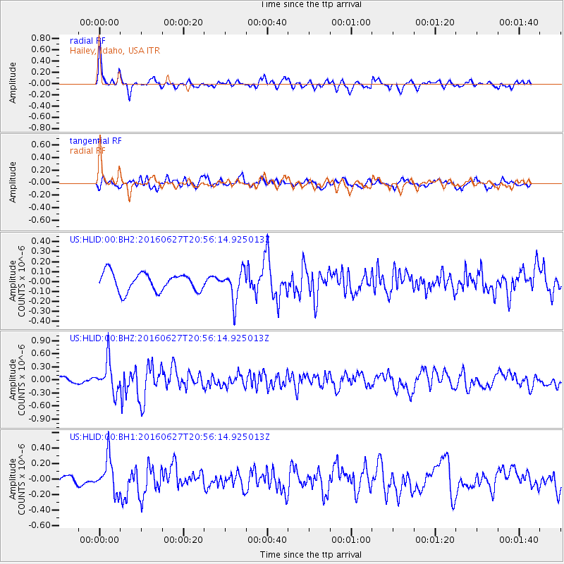
HLID Hailey, Idaho, USA - Earthquake Result Viewer
*The percent match for this event was below the threshold and hence no stack was calculated.
| Earthquake location: |
Oaxaca, Mexico |
| Earthquake latitude/longitude: |
16.6/-97.8 |
| Earthquake time(UTC): |
2016/06/27 (179) 20:50:34 GMT |
| Earthquake Depth: |
19 km |
| Earthquake Magnitude: |
5.7 MWW, 5.5 MWB |
| Earthquake Catalog/Contributor: |
NEIC PDE/NEIC COMCAT |
|
| Network: |
US United States National Seismic Network |
| Station: |
HLID Hailey, Idaho, USA |
| Lat/Lon: |
43.56 N/114.41 W |
| Elevation: |
1772 m |
|
| Distance: |
30.4 deg |
| Az: |
335.785 deg |
| Baz: |
147.241 deg |
| Ray Param: |
$rayparam |
*The percent match for this event was below the threshold and hence was not used in the summary stack. |
|
| Radial Match: |
73.11314 % |
| Radial Bump: |
377 |
| Transverse Match: |
66.05756 % |
| Transverse Bump: |
400 |
| SOD ConfigId: |
1634031 |
| Insert Time: |
2016-07-11 20:53:40.334 +0000 |
| GWidth: |
2.5 |
| Max Bumps: |
400 |
| Tol: |
0.001 |
|
Signal To Noise
| Channel | StoN | STA | LTA |
| US:HLID:00:BHZ:20160627T20:56:14.925013Z | 5.2451677 | 3.7681502E-7 | 7.184041E-8 |
| US:HLID:00:BH1:20160627T20:56:14.925013Z | 3.8534348 | 2.293002E-7 | 5.9505403E-8 |
| US:HLID:00:BH2:20160627T20:56:14.925013Z | 1.7268019 | 1.5750665E-7 | 9.1212925E-8 |
| Arrivals |
| Ps | |
| PpPs | |
| PsPs/PpSs | |


