You are here: Home > Network List > TA - USArray Transportable Network (new EarthScope stations) Stations List
> Station U19A Dine' College, Tsaile, AZ, USA > Earthquake Result Viewer
U19A Dine' College, Tsaile, AZ, USA - Earthquake Result Viewer
| Earthquake location: |
Kuril Islands |
| Earthquake latitude/longitude: |
46.4/153.2 |
| Earthquake time(UTC): |
2008/03/03 (063) 09:31:02 GMT |
| Earthquake Depth: |
10 km |
| Earthquake Magnitude: |
6.2 MB, 6.5 MS, 6.5 MW, 6.5 MW |
| Earthquake Catalog/Contributor: |
WHDF/NEIC |
|
| Network: |
TA USArray Transportable Network (new EarthScope stations) |
| Station: |
U19A Dine' College, Tsaile, AZ, USA |
| Lat/Lon: |
36.29 N/109.21 W |
| Elevation: |
2166 m |
|
| Distance: |
69.4 deg |
| Az: |
58.792 deg |
| Baz: |
312.898 deg |
| Ray Param: |
0.055652518 |
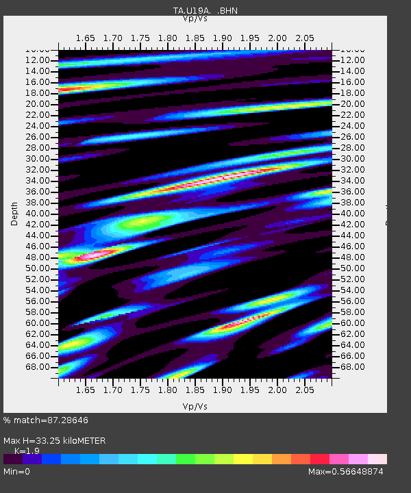
| Estimated Moho Depth: |
33.25 km |
| Estimated Crust Vp/Vs: |
1.90 |
| Assumed Crust Vp: |
6.476 km/s |
| Estimated Crust Vs: |
3.408 km/s |
| Estimated Crust Poisson's Ratio: |
0.31 |
|
| Radial Match: |
87.28646 % |
| Radial Bump: |
400 |
| Transverse Match: |
59.786324 % |
| Transverse Bump: |
400 |
| SOD ConfigId: |
2564 |
| Insert Time: |
2010-03-06 14:40:55.390 +0000 |
| GWidth: |
2.5 |
| Max Bumps: |
400 |
| Tol: |
0.001 |
|

Signal To Noise
| Channel | StoN | STA | LTA |
| TA:U19A: :BHN:20080303T09:41:39.450012Z | 1.9345442 | 2.3579472E-7 | 1.2188644E-7 |
| TA:U19A: :BHE:20080303T09:41:39.450012Z | 2.401726 | 1.8561786E-7 | 7.72852E-8 |
| TA:U19A: :BHZ:20080303T09:41:39.450012Z | 1.3535336 | 2.9723046E-7 | 2.1959592E-7 |
| Arrivals |
| Ps | 4.8 SECOND |
| PpPs | 14 SECOND |
| PsPs/PpSs | 19 SECOND |


