You are here: Home > Network List > TA - USArray Transportable Network (new EarthScope stations) Stations List
> Station R33M Jennings River, BC, CAN > Earthquake Result Viewer
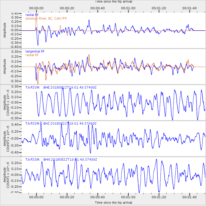
R33M Jennings River, BC, CAN - Earthquake Result Viewer
*The percent match for this event was below the threshold and hence no stack was calculated.
| Earthquake location: |
Solomon Islands |
| Earthquake latitude/longitude: |
-7.0/155.7 |
| Earthquake time(UTC): |
2018/08/22 (234) 18:49:36 GMT |
| Earthquake Depth: |
34 km |
| Earthquake Magnitude: |
5.8 Mww |
| Earthquake Catalog/Contributor: |
NEIC PDE/us |
|
| Network: |
TA USArray Transportable Network (new EarthScope stations) |
| Station: |
R33M Jennings River, BC, CAN |
| Lat/Lon: |
59.39 N/130.97 W |
| Elevation: |
1437 m |
|
| Distance: |
87.6 deg |
| Az: |
29.376 deg |
| Baz: |
252.133 deg |
| Ray Param: |
$rayparam |
*The percent match for this event was below the threshold and hence was not used in the summary stack. |
|
| Radial Match: |
35.631638 % |
| Radial Bump: |
349 |
| Transverse Match: |
62.600147 % |
| Transverse Bump: |
400 |
| SOD ConfigId: |
13570011 |
| Insert Time: |
2019-04-30 23:17:10.173 +0000 |
| GWidth: |
2.5 |
| Max Bumps: |
400 |
| Tol: |
0.001 |
|
Signal To Noise
| Channel | StoN | STA | LTA |
| TA:R33M: :BHZ:20180822T19:01:49.37499Z | 1.7429034 | 1.9381919E-7 | 1.1120478E-7 |
| TA:R33M: :BHN:20180822T19:01:49.37499Z | 1.1522576 | 1.0048342E-7 | 8.720569E-8 |
| TA:R33M: :BHE:20180822T19:01:49.37499Z | 0.7143029 | 1.2016561E-7 | 1.682278E-7 |
| Arrivals |
| Ps | |
| PpPs | |
| PsPs/PpSs | |


