You are here: Home > Network List > TA - USArray Transportable Network (new EarthScope stations) Stations List
> Station U19A Dine' College, Tsaile, AZ, USA > Earthquake Result Viewer
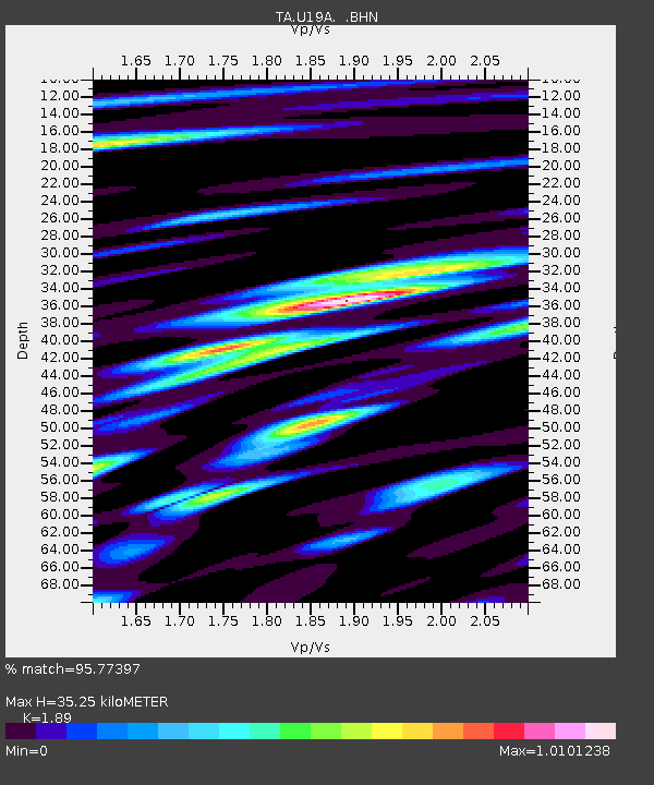
U19A Dine' College, Tsaile, AZ, USA - Earthquake Result Viewer
| Earthquake location: |
Sea Of Okhotsk |
| Earthquake latitude/longitude: |
53.9/152.9 |
| Earthquake time(UTC): |
2008/07/05 (187) 02:12:04 GMT |
| Earthquake Depth: |
633 km |
| Earthquake Magnitude: |
6.8 MB, 7.7 MW, 7.7 MW |
| Earthquake Catalog/Contributor: |
WHDF/NEIC |
|
| Network: |
TA USArray Transportable Network (new EarthScope stations) |
| Station: |
U19A Dine' College, Tsaile, AZ, USA |
| Lat/Lon: |
36.29 N/109.21 W |
| Elevation: |
2166 m |
|
| Distance: |
65.8 deg |
| Az: |
61.28 deg |
| Baz: |
320.01 deg |
| Ray Param: |
0.05562327 |
| Estimated Moho Depth: |
35.25 km |
| Estimated Crust Vp/Vs: |
1.89 |
| Assumed Crust Vp: |
6.476 km/s |
| Estimated Crust Vs: |
3.426 km/s |
| Estimated Crust Poisson's Ratio: |
0.31 |
|
| Radial Match: |
95.77397 % |
| Radial Bump: |
400 |
| Transverse Match: |
88.591606 % |
| Transverse Bump: |
400 |
| SOD ConfigId: |
2504 |
| Insert Time: |
2010-03-06 14:41:12.251 +0000 |
| GWidth: |
2.5 |
| Max Bumps: |
400 |
| Tol: |
0.001 |
|

Signal To Noise
| Channel | StoN | STA | LTA |
| TA:U19A: :BHN:20080705T02:21:18.448994Z | 50.16083 | 5.023995E-6 | 1.0015773E-7 |
| TA:U19A: :BHE:20080705T02:21:18.448994Z | 35.44425 | 2.1487658E-6 | 6.0623826E-8 |
| TA:U19A: :BHZ:20080705T02:21:18.448994Z | 19.354786 | 1.4496505E-6 | 7.489882E-8 |
| Arrivals |
| Ps | 5.0 SECOND |
| PpPs | 15 SECOND |
| PsPs/PpSs | 20 SECOND |


