You are here: Home > Network List > 5H - Central Virginia and South Carolina seismic monitoring experiment Stations List
> Station DEBI Ferncliff, VA > Earthquake Result Viewer
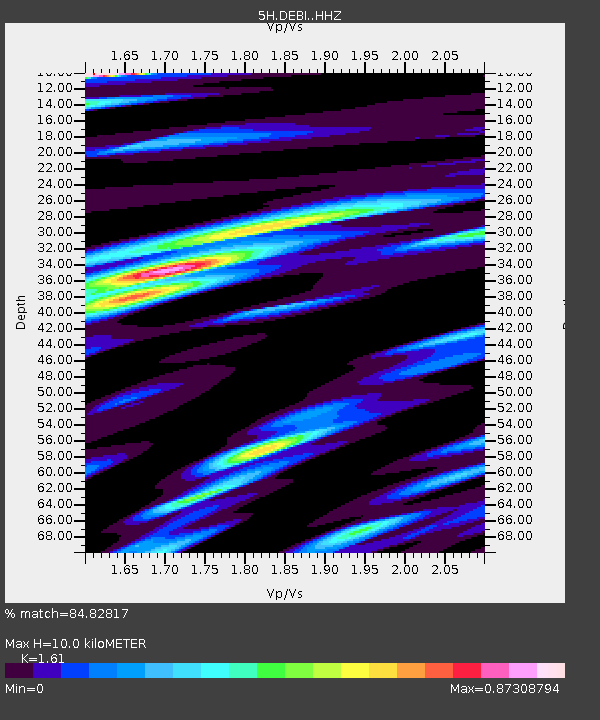
DEBI Ferncliff, VA - Earthquake Result Viewer
| Earthquake location: |
Andreanof Islands, Aleutian Is. |
| Earthquake latitude/longitude: |
51.5/-177.9 |
| Earthquake time(UTC): |
2018/08/23 (235) 03:35:15 GMT |
| Earthquake Depth: |
44 km |
| Earthquake Magnitude: |
6.0 Ml |
| Earthquake Catalog/Contributor: |
NEIC PDE/us |
|
| Network: |
5H Central Virginia and South Carolina seismic monitoring experiment |
| Station: |
DEBI Ferncliff, VA |
| Lat/Lon: |
37.92 N/78.10 W |
| Elevation: |
137 m |
|
| Distance: |
66.8 deg |
| Az: |
57.98 deg |
| Baz: |
317.934 deg |
| Ray Param: |
0.05728539 |
| Estimated Moho Depth: |
10.0 km |
| Estimated Crust Vp/Vs: |
1.61 |
| Assumed Crust Vp: |
6.419 km/s |
| Estimated Crust Vs: |
3.987 km/s |
| Estimated Crust Poisson's Ratio: |
0.19 |
|
| Radial Match: |
84.82817 % |
| Radial Bump: |
400 |
| Transverse Match: |
29.761326 % |
| Transverse Bump: |
400 |
| SOD ConfigId: |
13570011 |
| Insert Time: |
2019-04-30 23:22:56.195 +0000 |
| GWidth: |
2.5 |
| Max Bumps: |
400 |
| Tol: |
0.001 |
|

Signal To Noise
| Channel | StoN | STA | LTA |
| 5H:DEBI: :HHZ:20180823T03:45:32.234973Z | 15.272467 | 1.5035273E-6 | 9.844692E-8 |
| 5H:DEBI: :HHN:20180823T03:45:32.234973Z | 2.0221696 | 4.603149E-7 | 2.2763416E-7 |
| 5H:DEBI: :HHE:20180823T03:45:32.234973Z | 1.2478987 | 5.4695454E-7 | 4.3830042E-7 |
| Arrivals |
| Ps | 1.0 SECOND |
| PpPs | 3.9 SECOND |
| PsPs/PpSs | 4.9 SECOND |


