You are here: Home > Network List > CC - Cascade Chain Volcano Monitoring Stations List
> Station VALT Mt. St. Helens Crater, WA > Earthquake Result Viewer
VALT Mt. St. Helens Crater, WA - Earthquake Result Viewer
| Earthquake location: |
Andreanof Islands, Aleutian Is. |
| Earthquake latitude/longitude: |
51.5/-177.9 |
| Earthquake time(UTC): |
2018/08/23 (235) 03:35:15 GMT |
| Earthquake Depth: |
44 km |
| Earthquake Magnitude: |
6.0 Ml |
| Earthquake Catalog/Contributor: |
NEIC PDE/us |
|
| Network: |
CC Cascade Chain Volcano Monitoring |
| Station: |
VALT Mt. St. Helens Crater, WA |
| Lat/Lon: |
46.21 N/122.19 W |
| Elevation: |
1681 m |
|
| Distance: |
36.3 deg |
| Az: |
75.892 deg |
| Baz: |
299.21 deg |
| Ray Param: |
0.076677285 |
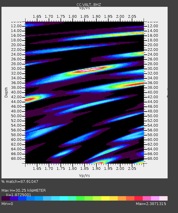
| Estimated Moho Depth: |
30.25 km |
| Estimated Crust Vp/Vs: |
1.87 |
| Assumed Crust Vp: |
6.566 km/s |
| Estimated Crust Vs: |
3.507 km/s |
| Estimated Crust Poisson's Ratio: |
0.30 |
|
| Radial Match: |
87.91047 % |
| Radial Bump: |
400 |
| Transverse Match: |
83.3431 % |
| Transverse Bump: |
400 |
| SOD ConfigId: |
13570011 |
| Insert Time: |
2019-04-30 23:24:45.553 +0000 |
| GWidth: |
2.5 |
| Max Bumps: |
400 |
| Tol: |
0.001 |
|

Signal To Noise
| Channel | StoN | STA | LTA |
| CC:VALT: :BHZ:20180823T03:41:44.580005Z | 9.340412 | 1.9497122E-6 | 2.0873942E-7 |
| CC:VALT: :BHN:20180823T03:41:44.580005Z | 3.2058766 | 1.233822E-6 | 3.8486257E-7 |
| CC:VALT: :BHE:20180823T03:41:44.580005Z | 3.1005287 | 1.3151846E-6 | 4.2418074E-7 |
| Arrivals |
| Ps | 4.3 SECOND |
| PpPs | 12 SECOND |
| PsPs/PpSs | 17 SECOND |


