You are here: Home > Network List > CN - Canadian National Seismograph Network Stations List
> Station A16 Riviere Ouelle, QC, CA > Earthquake Result Viewer
A16 Riviere Ouelle, QC, CA - Earthquake Result Viewer
| Earthquake location: |
Andreanof Islands, Aleutian Is. |
| Earthquake latitude/longitude: |
51.5/-177.9 |
| Earthquake time(UTC): |
2018/08/23 (235) 03:35:15 GMT |
| Earthquake Depth: |
44 km |
| Earthquake Magnitude: |
6.0 Ml |
| Earthquake Catalog/Contributor: |
NEIC PDE/us |
|
| Network: |
CN Canadian National Seismograph Network |
| Station: |
A16 Riviere Ouelle, QC, CA |
| Lat/Lon: |
47.47 N/70.01 W |
| Elevation: |
13 m |
|
| Distance: |
63.7 deg |
| Az: |
46.089 deg |
| Baz: |
318.427 deg |
| Ray Param: |
0.059332214 |
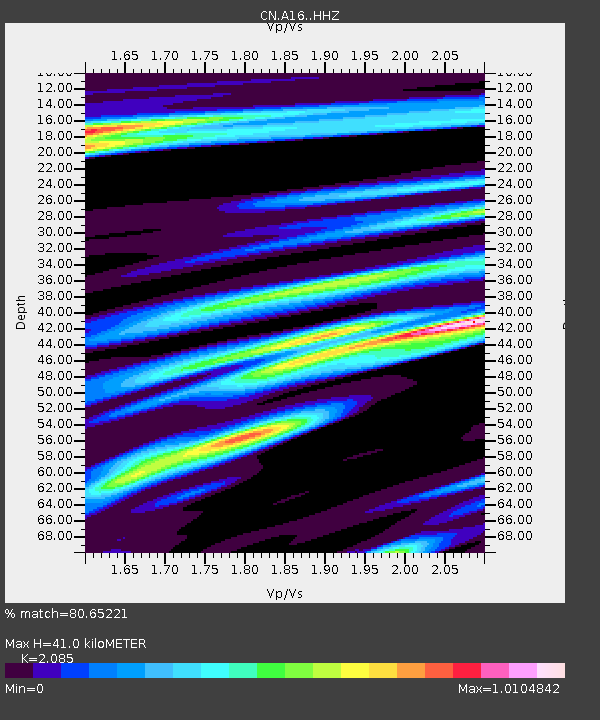
| Estimated Moho Depth: |
41.0 km |
| Estimated Crust Vp/Vs: |
2.09 |
| Assumed Crust Vp: |
6.61 km/s |
| Estimated Crust Vs: |
3.17 km/s |
| Estimated Crust Poisson's Ratio: |
0.35 |
|
| Radial Match: |
80.65221 % |
| Radial Bump: |
400 |
| Transverse Match: |
42.443897 % |
| Transverse Bump: |
383 |
| SOD ConfigId: |
13570011 |
| Insert Time: |
2019-04-30 23:25:39.284 +0000 |
| GWidth: |
2.5 |
| Max Bumps: |
400 |
| Tol: |
0.001 |
|

Signal To Noise
| Channel | StoN | STA | LTA |
| CN:A16: :HHZ:20180823T03:45:12.030017Z | 2.5409274 | 8.0584374E-7 | 3.1714552E-7 |
| CN:A16: :HHN:20180823T03:45:12.030017Z | 0.8501872 | 3.530645E-7 | 4.1527858E-7 |
| CN:A16: :HHE:20180823T03:45:12.030017Z | 0.9646451 | 2.0847936E-7 | 2.1612027E-7 |
| Arrivals |
| Ps | 7.0 SECOND |
| PpPs | 18 SECOND |
| PsPs/PpSs | 25 SECOND |


