You are here: Home > Network List > LD - Lamont-Doherty Cooperative Seismographic Network Stations List
> Station BMNY Brushton-Moira, New York > Earthquake Result Viewer
BMNY Brushton-Moira, New York - Earthquake Result Viewer
| Earthquake location: |
Andreanof Islands, Aleutian Is. |
| Earthquake latitude/longitude: |
51.5/-177.9 |
| Earthquake time(UTC): |
2018/08/23 (235) 03:35:15 GMT |
| Earthquake Depth: |
44 km |
| Earthquake Magnitude: |
6.0 Ml |
| Earthquake Catalog/Contributor: |
NEIC PDE/us |
|
| Network: |
LD Lamont-Doherty Cooperative Seismographic Network |
| Station: |
BMNY Brushton-Moira, New York |
| Lat/Lon: |
44.84 N/74.51 W |
| Elevation: |
115 m |
|
| Distance: |
63.5 deg |
| Az: |
50.644 deg |
| Baz: |
317.219 deg |
| Ray Param: |
0.059432264 |
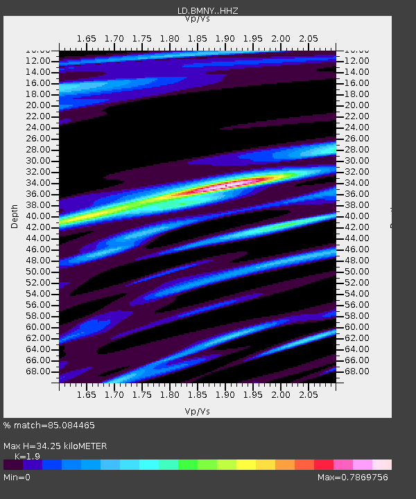
| Estimated Moho Depth: |
34.25 km |
| Estimated Crust Vp/Vs: |
1.90 |
| Assumed Crust Vp: |
6.419 km/s |
| Estimated Crust Vs: |
3.379 km/s |
| Estimated Crust Poisson's Ratio: |
0.31 |
|
| Radial Match: |
85.084465 % |
| Radial Bump: |
356 |
| Transverse Match: |
56.995426 % |
| Transverse Bump: |
400 |
| SOD ConfigId: |
13570011 |
| Insert Time: |
2019-04-30 23:28:05.398 +0000 |
| GWidth: |
2.5 |
| Max Bumps: |
400 |
| Tol: |
0.001 |
|

Signal To Noise
| Channel | StoN | STA | LTA |
| LD:BMNY: :HHZ:20180823T03:45:11.030017Z | 4.4206266 | 7.3596374E-7 | 1.6648404E-7 |
| LD:BMNY: :HHN:20180823T03:45:11.030017Z | 1.2429088 | 2.1992324E-7 | 1.7694236E-7 |
| LD:BMNY: :HHE:20180823T03:45:11.030017Z | 2.211925 | 3.6033E-7 | 1.6290336E-7 |
| Arrivals |
| Ps | 5.0 SECOND |
| PpPs | 15 SECOND |
| PsPs/PpSs | 20 SECOND |


