You are here: Home > Network List > MM - Myanmar National Seismic Network Stations List
> Station HKA Haka, Chin, Myanmar > Earthquake Result Viewer
HKA Haka, Chin, Myanmar - Earthquake Result Viewer
| Earthquake location: |
Andreanof Islands, Aleutian Is. |
| Earthquake latitude/longitude: |
51.5/-177.9 |
| Earthquake time(UTC): |
2018/08/23 (235) 03:35:15 GMT |
| Earthquake Depth: |
44 km |
| Earthquake Magnitude: |
6.0 Ml |
| Earthquake Catalog/Contributor: |
NEIC PDE/us |
|
| Network: |
MM Myanmar National Seismic Network |
| Station: |
HKA Haka, Chin, Myanmar |
| Lat/Lon: |
22.64 N/93.60 E |
| Elevation: |
1733 m |
|
| Distance: |
71.7 deg |
| Az: |
283.433 deg |
| Baz: |
41.143 deg |
| Ray Param: |
0.054062735 |
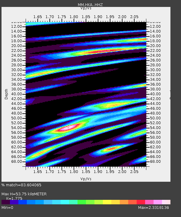
| Estimated Moho Depth: |
53.75 km |
| Estimated Crust Vp/Vs: |
1.77 |
| Assumed Crust Vp: |
6.552 km/s |
| Estimated Crust Vs: |
3.692 km/s |
| Estimated Crust Poisson's Ratio: |
0.27 |
|
| Radial Match: |
83.604065 % |
| Radial Bump: |
400 |
| Transverse Match: |
79.20174 % |
| Transverse Bump: |
400 |
| SOD ConfigId: |
13570011 |
| Insert Time: |
2019-04-30 23:28:35.626 +0000 |
| GWidth: |
2.5 |
| Max Bumps: |
400 |
| Tol: |
0.001 |
|

Signal To Noise
| Channel | StoN | STA | LTA |
| MM:HKA: :HHZ:20180823T03:46:02.517993Z | 21.637892 | 2.7705064E-6 | 1.2803957E-7 |
| MM:HKA: :HHN:20180823T03:46:02.517993Z | 5.669806 | 9.7912E-7 | 1.7269022E-7 |
| MM:HKA: :HHE:20180823T03:46:02.517993Z | 8.61427 | 1.5015503E-6 | 1.7430963E-7 |
| Arrivals |
| Ps | 6.6 SECOND |
| PpPs | 22 SECOND |
| PsPs/PpSs | 29 SECOND |


