You are here: Home > Network List > MU - Miami University Seismic Network Stations List
> Station MUH1 Harrison > Earthquake Result Viewer
MUH1 Harrison - Earthquake Result Viewer
| Earthquake location: |
Andreanof Islands, Aleutian Is. |
| Earthquake latitude/longitude: |
51.5/-177.9 |
| Earthquake time(UTC): |
2018/08/23 (235) 03:35:15 GMT |
| Earthquake Depth: |
44 km |
| Earthquake Magnitude: |
6.0 Ml |
| Earthquake Catalog/Contributor: |
NEIC PDE/us |
|
| Network: |
MU Miami University Seismic Network |
| Station: |
MUH1 Harrison |
| Lat/Lon: |
40.23 N/81.15 W |
| Elevation: |
365 m |
|
| Distance: |
63.5 deg |
| Az: |
58.162 deg |
| Baz: |
316.097 deg |
| Ray Param: |
0.05944575 |
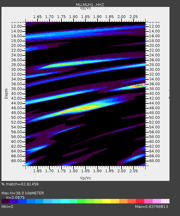
| Estimated Moho Depth: |
36.0 km |
| Estimated Crust Vp/Vs: |
2.10 |
| Assumed Crust Vp: |
6.483 km/s |
| Estimated Crust Vs: |
3.091 km/s |
| Estimated Crust Poisson's Ratio: |
0.35 |
|
| Radial Match: |
82.61459 % |
| Radial Bump: |
400 |
| Transverse Match: |
74.36413 % |
| Transverse Bump: |
400 |
| SOD ConfigId: |
13570011 |
| Insert Time: |
2019-04-30 23:28:47.163 +0000 |
| GWidth: |
2.5 |
| Max Bumps: |
400 |
| Tol: |
0.001 |
|

Signal To Noise
| Channel | StoN | STA | LTA |
| MU:MUH1: :HHZ:20180823T03:45:10.890002Z | 9.540515 | 4.8734264E-6 | 5.108138E-7 |
| MU:MUH1: :HHN:20180823T03:45:10.890002Z | 2.691874 | 1.9859085E-6 | 7.377419E-7 |
| MU:MUH1: :HHE:20180823T03:45:10.890002Z | 2.889285 | 1.3331933E-6 | 4.6142668E-7 |
| Arrivals |
| Ps | 6.3 SECOND |
| PpPs | 17 SECOND |
| PsPs/PpSs | 23 SECOND |


