You are here: Home > Network List > N4 - Central and EAstern US Network Stations List
> Station I42A Draeger Farm, Ripon, WI, USA > Earthquake Result Viewer
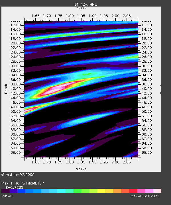
I42A Draeger Farm, Ripon, WI, USA - Earthquake Result Viewer
| Earthquake location: |
Andreanof Islands, Aleutian Is. |
| Earthquake latitude/longitude: |
51.5/-177.9 |
| Earthquake time(UTC): |
2018/08/23 (235) 03:35:15 GMT |
| Earthquake Depth: |
44 km |
| Earthquake Magnitude: |
6.0 Ml |
| Earthquake Catalog/Contributor: |
NEIC PDE/us |
|
| Network: |
N4 Central and EAstern US Network |
| Station: |
I42A Draeger Farm, Ripon, WI, USA |
| Lat/Lon: |
43.89 N/88.91 W |
| Elevation: |
298 m |
|
| Distance: |
56.8 deg |
| Az: |
59.75 deg |
| Baz: |
311.697 deg |
| Ray Param: |
0.063804924 |
| Estimated Moho Depth: |
40.75 km |
| Estimated Crust Vp/Vs: |
1.72 |
| Assumed Crust Vp: |
6.571 km/s |
| Estimated Crust Vs: |
3.815 km/s |
| Estimated Crust Poisson's Ratio: |
0.25 |
|
| Radial Match: |
92.9009 % |
| Radial Bump: |
288 |
| Transverse Match: |
61.798225 % |
| Transverse Bump: |
400 |
| SOD ConfigId: |
13570011 |
| Insert Time: |
2019-04-30 23:29:20.012 +0000 |
| GWidth: |
2.5 |
| Max Bumps: |
400 |
| Tol: |
0.001 |
|

Signal To Noise
| Channel | StoN | STA | LTA |
| N4:I42A: :HHZ:20180823T03:44:25.129993Z | 6.812713 | 1.3146412E-6 | 1.929688E-7 |
| N4:I42A: :HHN:20180823T03:44:25.129993Z | 4.9371743 | 3.9332238E-7 | 7.966548E-8 |
| N4:I42A: :HHE:20180823T03:44:25.129993Z | 2.5106606 | 4.3169732E-7 | 1.719457E-7 |
| Arrivals |
| Ps | 4.7 SECOND |
| PpPs | 16 SECOND |
| PsPs/PpSs | 21 SECOND |


