You are here: Home > Network List > TA - USArray Transportable Network (new EarthScope stations) Stations List
> Station 324A Moseley Ranch, Sierra Blanca, TX, USA > Earthquake Result Viewer
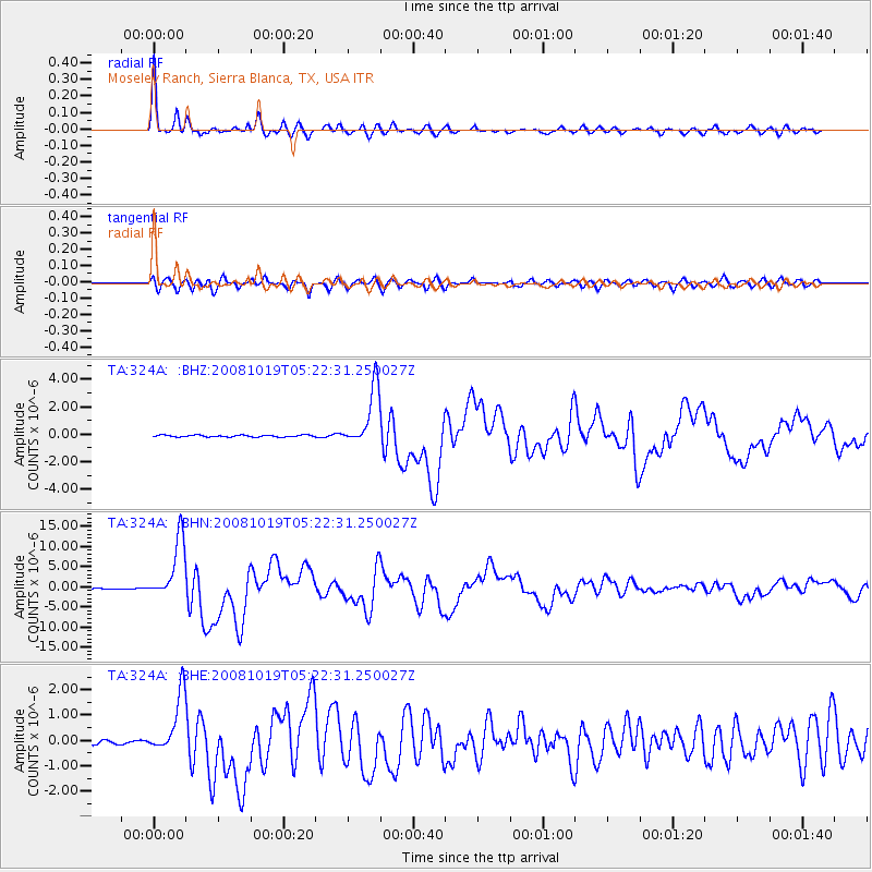
324A Moseley Ranch, Sierra Blanca, TX, USA - Earthquake Result Viewer

| Earthquake location: |
Tonga Islands |
| Earthquake latitude/longitude: |
-21.9/-173.8 |
| Earthquake time(UTC): |
2008/10/19 (293) 05:10:33 GMT |
| Earthquake Depth: |
29 km |
| Earthquake Magnitude: |
6.8 MB, 7.0 MS, 6.9 MW, 6.9 MW |
| Earthquake Catalog/Contributor: |
WHDF/NEIC |
|
| Network: |
TA USArray Transportable Network (new EarthScope stations) |
| Station: |
324A Moseley Ranch, Sierra Blanca, TX, USA |
| Lat/Lon: |
31.44 N/105.48 W |
| Elevation: |
1441 m |
|
| Distance: |
84.2 deg |
| Az: |
52.98 deg |
| Baz: |
240.198 deg |
| Ray Param: |
0.04561068 |
| Estimated Moho Depth: |
36.5 km |
| Estimated Crust Vp/Vs: |
1.88 |
| Assumed Crust Vp: |
6.361 km/s |
| Estimated Crust Vs: |
3.379 km/s |
| Estimated Crust Poisson's Ratio: |
0.30 |
|
| Radial Match: |
97.407074 % |
| Radial Bump: |
319 |
| Transverse Match: |
93.598305 % |
| Transverse Bump: |
400 |
| SOD ConfigId: |
2556 |
| Insert Time: |
2010-03-06 14:42:48.853 +0000 |
| GWidth: |
2.5 |
| Max Bumps: |
400 |
| Tol: |
0.001 |
|
Signal To Noise
| Channel | StoN | STA | LTA |
| TA:324A: :BHN:20081019T05:22:31.250027Z | 94.14936 | 7.5371486E-6 | 8.005523E-8 |
| TA:324A: :BHE:20081019T05:22:31.250027Z | 9.755492 | 1.1714919E-6 | 1.2008537E-7 |
| TA:324A: :BHZ:20081019T05:22:31.250027Z | 32.80454 | 2.158312E-6 | 6.5793095E-8 |
| Arrivals |
| Ps | 5.2 SECOND |
| PpPs | 16 SECOND |
| PsPs/PpSs | 21 SECOND |


