You are here: Home > Network List > TA - USArray Transportable Network (new EarthScope stations) Stations List
> Station 324A Moseley Ranch, Sierra Blanca, TX, USA > Earthquake Result Viewer
324A Moseley Ranch, Sierra Blanca, TX, USA - Earthquake Result Viewer
| Earthquake location: |
Central Mid-Atlantic Ridge |
| Earthquake latitude/longitude: |
8.1/-38.7 |
| Earthquake time(UTC): |
2008/09/10 (254) 13:08:14 GMT |
| Earthquake Depth: |
10 km |
| Earthquake Magnitude: |
6.3 MB, 6.5 MS, 6.6 MW, 6.6 MW |
| Earthquake Catalog/Contributor: |
WHDF/NEIC |
|
| Network: |
TA USArray Transportable Network (new EarthScope stations) |
| Station: |
324A Moseley Ranch, Sierra Blanca, TX, USA |
| Lat/Lon: |
31.44 N/105.48 W |
| Elevation: |
1441 m |
|
| Distance: |
66.0 deg |
| Az: |
300.727 deg |
| Baz: |
95.228 deg |
| Ray Param: |
0.057891898 |
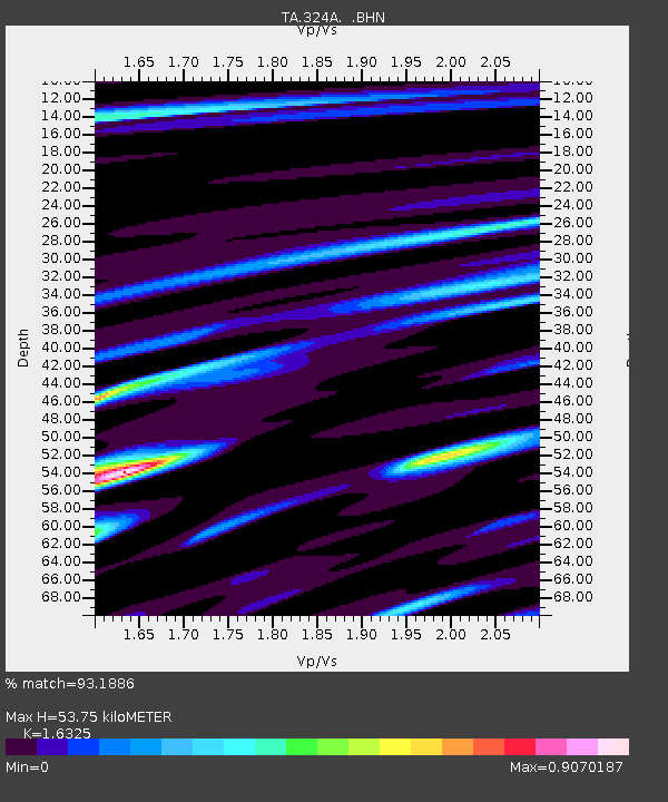
| Estimated Moho Depth: |
53.75 km |
| Estimated Crust Vp/Vs: |
1.63 |
| Assumed Crust Vp: |
6.361 km/s |
| Estimated Crust Vs: |
3.896 km/s |
| Estimated Crust Poisson's Ratio: |
0.20 |
|
| Radial Match: |
93.1886 % |
| Radial Bump: |
400 |
| Transverse Match: |
81.79401 % |
| Transverse Bump: |
400 |
| SOD ConfigId: |
2560 |
| Insert Time: |
2010-03-06 14:42:53.232 +0000 |
| GWidth: |
2.5 |
| Max Bumps: |
400 |
| Tol: |
0.001 |
|

Signal To Noise
| Channel | StoN | STA | LTA |
| TA:324A: :BHN:20080910T13:18:30.375027Z | 6.1452684 | 8.286063E-7 | 1.3483647E-7 |
| TA:324A: :BHE:20080910T13:18:30.375027Z | 1.1999319 | 1.0425354E-7 | 8.688288E-8 |
| TA:324A: :BHZ:20080910T13:18:30.375027Z | 3.5699925 | 2.2111516E-7 | 6.193714E-8 |
| Arrivals |
| Ps | 5.6 SECOND |
| PpPs | 21 SECOND |
| PsPs/PpSs | 27 SECOND |


