You are here: Home > Network List > TA - USArray Transportable Network (new EarthScope stations) Stations List
> Station 324A Moseley Ranch, Sierra Blanca, TX, USA > Earthquake Result Viewer
324A Moseley Ranch, Sierra Blanca, TX, USA - Earthquake Result Viewer
| Earthquake location: |
East Of Kuril Islands |
| Earthquake latitude/longitude: |
46.9/155.2 |
| Earthquake time(UTC): |
2009/01/15 (015) 17:49:39 GMT |
| Earthquake Depth: |
36 km |
| Earthquake Magnitude: |
6.9 MB, 7.5 MS, 7.4 MW, 7.4 MW |
| Earthquake Catalog/Contributor: |
WHDF/NEIC |
|
| Network: |
TA USArray Transportable Network (new EarthScope stations) |
| Station: |
324A Moseley Ranch, Sierra Blanca, TX, USA |
| Lat/Lon: |
31.44 N/105.48 W |
| Elevation: |
1441 m |
|
| Distance: |
73.6 deg |
| Az: |
61.527 deg |
| Baz: |
315.106 deg |
| Ray Param: |
0.052832626 |
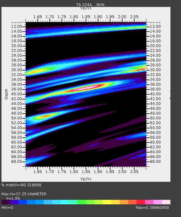
| Estimated Moho Depth: |
37.25 km |
| Estimated Crust Vp/Vs: |
1.85 |
| Assumed Crust Vp: |
6.361 km/s |
| Estimated Crust Vs: |
3.438 km/s |
| Estimated Crust Poisson's Ratio: |
0.29 |
|
| Radial Match: |
98.316986 % |
| Radial Bump: |
224 |
| Transverse Match: |
92.41437 % |
| Transverse Bump: |
400 |
| SOD ConfigId: |
2834 |
| Insert Time: |
2010-03-06 14:42:59.491 +0000 |
| GWidth: |
2.5 |
| Max Bumps: |
400 |
| Tol: |
0.001 |
|

Signal To Noise
| Channel | StoN | STA | LTA |
| TA:324A: :BHN:20090115T18:00:37.749016Z | 27.32742 | 1.0836771E-5 | 3.9655305E-7 |
| TA:324A: :BHE:20090115T18:00:37.749016Z | 9.683574 | 3.4540947E-6 | 3.566963E-7 |
| TA:324A: :BHZ:20090115T18:00:37.749016Z | 5.6339445 | 3.0733115E-6 | 5.4549906E-7 |
| Arrivals |
| Ps | 5.1 SECOND |
| PpPs | 16 SECOND |
| PsPs/PpSs | 21 SECOND |


