You are here: Home > Network List > TA - USArray Transportable Network (new EarthScope stations) Stations List
> Station 324A Moseley Ranch, Sierra Blanca, TX, USA > Earthquake Result Viewer
324A Moseley Ranch, Sierra Blanca, TX, USA - Earthquake Result Viewer
| Earthquake location: |
Kuril Islands |
| Earthquake latitude/longitude: |
48.3/154.2 |
| Earthquake time(UTC): |
2009/09/10 (253) 02:46:50 GMT |
| Earthquake Depth: |
36 km |
| Earthquake Magnitude: |
6.0 MB, 5.5 MS, 6.0 MW, 5.8 MW |
| Earthquake Catalog/Contributor: |
WHDF/NEIC |
|
| Network: |
TA USArray Transportable Network (new EarthScope stations) |
| Station: |
324A Moseley Ranch, Sierra Blanca, TX, USA |
| Lat/Lon: |
31.44 N/105.48 W |
| Elevation: |
1441 m |
|
| Distance: |
73.5 deg |
| Az: |
61.29 deg |
| Baz: |
316.769 deg |
| Ray Param: |
0.05291725 |
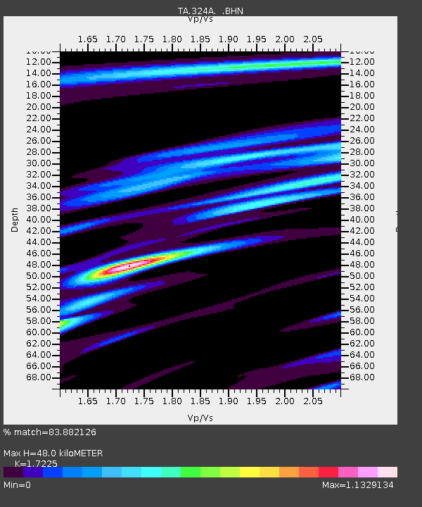
| Estimated Moho Depth: |
48.0 km |
| Estimated Crust Vp/Vs: |
1.72 |
| Assumed Crust Vp: |
6.361 km/s |
| Estimated Crust Vs: |
3.693 km/s |
| Estimated Crust Poisson's Ratio: |
0.25 |
|
| Radial Match: |
83.882126 % |
| Radial Bump: |
400 |
| Transverse Match: |
71.15037 % |
| Transverse Bump: |
400 |
| SOD ConfigId: |
2622 |
| Insert Time: |
2010-03-06 14:43:15.972 +0000 |
| GWidth: |
2.5 |
| Max Bumps: |
400 |
| Tol: |
0.001 |
|

Signal To Noise
| Channel | StoN | STA | LTA |
| TA:324A: :BHN:20090910T02:57:48.274011Z | 7.370441 | 5.036921E-7 | 6.8339475E-8 |
| TA:324A: :BHE:20090910T02:57:48.274011Z | 1.8779063 | 1.382055E-7 | 7.359553E-8 |
| TA:324A: :BHZ:20090910T02:57:48.274011Z | 1.9676378 | 1.6193034E-7 | 8.229683E-8 |
| Arrivals |
| Ps | 5.6 SECOND |
| PpPs | 20 SECOND |
| PsPs/PpSs | 25 SECOND |


