You are here: Home > Network List > TA - USArray Transportable Network (new EarthScope stations) Stations List
> Station 324A Moseley Ranch, Sierra Blanca, TX, USA > Earthquake Result Viewer
324A Moseley Ranch, Sierra Blanca, TX, USA - Earthquake Result Viewer
| Earthquake location: |
Fox Islands, Aleutian Islands |
| Earthquake latitude/longitude: |
52.8/-167.0 |
| Earthquake time(UTC): |
2009/10/13 (286) 05:37:23 GMT |
| Earthquake Depth: |
24 km |
| Earthquake Magnitude: |
6.0 MB, 6.1 MS, 6.5 MW, 6.5 MW |
| Earthquake Catalog/Contributor: |
WHDF/NEIC |
|
| Network: |
TA USArray Transportable Network (new EarthScope stations) |
| Station: |
324A Moseley Ranch, Sierra Blanca, TX, USA |
| Lat/Lon: |
31.44 N/105.48 W |
| Elevation: |
1441 m |
|
| Distance: |
48.7 deg |
| Az: |
90.625 deg |
| Baz: |
314.677 deg |
| Ray Param: |
0.06914711 |
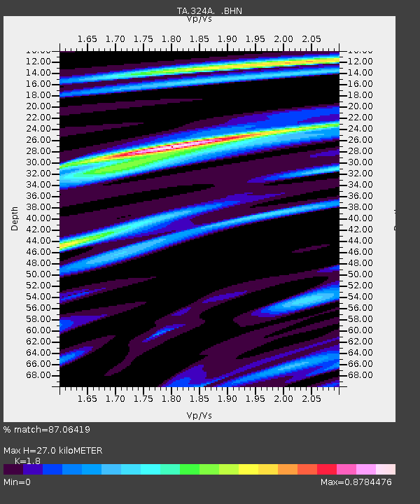
| Estimated Moho Depth: |
27.0 km |
| Estimated Crust Vp/Vs: |
1.80 |
| Assumed Crust Vp: |
6.361 km/s |
| Estimated Crust Vs: |
3.534 km/s |
| Estimated Crust Poisson's Ratio: |
0.28 |
|
| Radial Match: |
87.06419 % |
| Radial Bump: |
400 |
| Transverse Match: |
67.67578 % |
| Transverse Bump: |
400 |
| SOD ConfigId: |
2622 |
| Insert Time: |
2010-03-06 14:43:23.784 +0000 |
| GWidth: |
2.5 |
| Max Bumps: |
400 |
| Tol: |
0.001 |
|

Signal To Noise
| Channel | StoN | STA | LTA |
| TA:324A: :BHN:20091013T05:45:35.20001Z | 4.647803 | 4.54436E-7 | 9.7774375E-8 |
| TA:324A: :BHE:20091013T05:45:35.20001Z | 1.8089628 | 3.6765988E-7 | 2.0324347E-7 |
| TA:324A: :BHZ:20091013T05:45:35.20001Z | 1.3164873 | 1.8313555E-7 | 1.3910925E-7 |
| Arrivals |
| Ps | 3.6 SECOND |
| PpPs | 11 SECOND |
| PsPs/PpSs | 15 SECOND |


