You are here: Home > Network List > UO - University of Oregon Regional Network Stations List
> Station TOOM Fort Rock, OR, USA > Earthquake Result Viewer
TOOM Fort Rock, OR, USA - Earthquake Result Viewer
| Earthquake location: |
Andreanof Islands, Aleutian Is. |
| Earthquake latitude/longitude: |
51.5/-177.9 |
| Earthquake time(UTC): |
2018/08/23 (235) 03:35:15 GMT |
| Earthquake Depth: |
44 km |
| Earthquake Magnitude: |
6.0 Ml |
| Earthquake Catalog/Contributor: |
NEIC PDE/us |
|
| Network: |
UO University of Oregon Regional Network |
| Station: |
TOOM Fort Rock, OR, USA |
| Lat/Lon: |
43.28 N/121.23 W |
| Elevation: |
1541 m |
|
| Distance: |
38.3 deg |
| Az: |
79.459 deg |
| Baz: |
302.719 deg |
| Ray Param: |
0.07550797 |
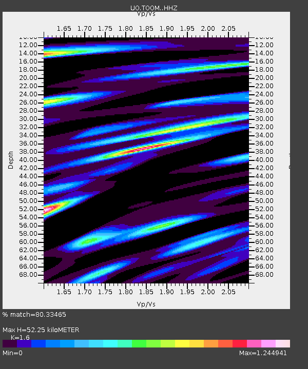
| Estimated Moho Depth: |
52.25 km |
| Estimated Crust Vp/Vs: |
1.60 |
| Assumed Crust Vp: |
6.597 km/s |
| Estimated Crust Vs: |
4.123 km/s |
| Estimated Crust Poisson's Ratio: |
0.18 |
|
| Radial Match: |
80.33465 % |
| Radial Bump: |
400 |
| Transverse Match: |
77.596565 % |
| Transverse Bump: |
400 |
| SOD ConfigId: |
13570011 |
| Insert Time: |
2019-04-30 23:34:49.668 +0000 |
| GWidth: |
2.5 |
| Max Bumps: |
400 |
| Tol: |
0.001 |
|

Signal To Noise
| Channel | StoN | STA | LTA |
| UO:TOOM: :HHZ:20180823T03:42:02.267993Z | 6.105702 | 1.095509E-6 | 1.7942394E-7 |
| UO:TOOM: :HHN:20180823T03:42:02.267993Z | 1.2155561 | 2.120895E-7 | 1.7447941E-7 |
| UO:TOOM: :HHE:20180823T03:42:02.267993Z | 6.3419895 | 7.628924E-7 | 1.2029227E-7 |
| Arrivals |
| Ps | 5.2 SECOND |
| PpPs | 19 SECOND |
| PsPs/PpSs | 24 SECOND |


