You are here: Home > Network List > UW - Pacific Northwest Regional Seismic Network Stations List
> Station LEBA Lebam, WA, USA > Earthquake Result Viewer
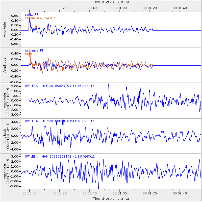
LEBA Lebam, WA, USA - Earthquake Result Viewer
*The percent match for this event was below the threshold and hence no stack was calculated.
| Earthquake location: |
Andreanof Islands, Aleutian Is. |
| Earthquake latitude/longitude: |
51.5/-177.9 |
| Earthquake time(UTC): |
2018/08/23 (235) 03:35:15 GMT |
| Earthquake Depth: |
44 km |
| Earthquake Magnitude: |
6.0 Ml |
| Earthquake Catalog/Contributor: |
NEIC PDE/us |
|
| Network: |
UW Pacific Northwest Regional Seismic Network |
| Station: |
LEBA Lebam, WA, USA |
| Lat/Lon: |
46.55 N/123.56 W |
| Elevation: |
73 m |
|
| Distance: |
35.3 deg |
| Az: |
76.18 deg |
| Baz: |
298.452 deg |
| Ray Param: |
$rayparam |
*The percent match for this event was below the threshold and hence was not used in the summary stack. |
|
| Radial Match: |
71.00641 % |
| Radial Bump: |
400 |
| Transverse Match: |
74.84901 % |
| Transverse Bump: |
400 |
| SOD ConfigId: |
13570011 |
| Insert Time: |
2019-04-30 23:35:30.301 +0000 |
| GWidth: |
2.5 |
| Max Bumps: |
400 |
| Tol: |
0.001 |
|
Signal To Noise
| Channel | StoN | STA | LTA |
| UW:LEBA: :HHZ:20180823T03:41:36.09801Z | 4.0533714 | 1.1173836E-6 | 2.756677E-7 |
| UW:LEBA: :HHN:20180823T03:41:36.09801Z | 1.1383158 | 3.3085075E-7 | 2.9064935E-7 |
| UW:LEBA: :HHE:20180823T03:41:36.09801Z | 1.7188376 | 5.733343E-7 | 3.335593E-7 |
| Arrivals |
| Ps | |
| PpPs | |
| PsPs/PpSs | |


