You are here: Home > Network List > UW - Pacific Northwest Regional Seismic Network Stations List
> Station SNI2 Snively Ranch 2, Hanford, WA, USA > Earthquake Result Viewer
SNI2 Snively Ranch 2, Hanford, WA, USA - Earthquake Result Viewer
| Earthquake location: |
Andreanof Islands, Aleutian Is. |
| Earthquake latitude/longitude: |
51.5/-177.9 |
| Earthquake time(UTC): |
2018/08/23 (235) 03:35:15 GMT |
| Earthquake Depth: |
44 km |
| Earthquake Magnitude: |
6.0 Ml |
| Earthquake Catalog/Contributor: |
NEIC PDE/us |
|
| Network: |
UW Pacific Northwest Regional Seismic Network |
| Station: |
SNI2 Snively Ranch 2, Hanford, WA, USA |
| Lat/Lon: |
46.46 N/119.66 W |
| Elevation: |
267 m |
|
| Distance: |
37.7 deg |
| Az: |
74.095 deg |
| Baz: |
299.602 deg |
| Ray Param: |
0.07590342 |
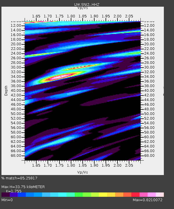
| Estimated Moho Depth: |
33.75 km |
| Estimated Crust Vp/Vs: |
1.75 |
| Assumed Crust Vp: |
6.419 km/s |
| Estimated Crust Vs: |
3.658 km/s |
| Estimated Crust Poisson's Ratio: |
0.26 |
|
| Radial Match: |
85.25917 % |
| Radial Bump: |
400 |
| Transverse Match: |
70.89636 % |
| Transverse Bump: |
400 |
| SOD ConfigId: |
13570011 |
| Insert Time: |
2019-04-30 23:35:39.711 +0000 |
| GWidth: |
2.5 |
| Max Bumps: |
400 |
| Tol: |
0.001 |
|

Signal To Noise
| Channel | StoN | STA | LTA |
| UW:SNI2: :HHZ:20180823T03:41:56.509998Z | 20.435835 | 1.7236673E-6 | 8.434534E-8 |
| UW:SNI2: :HHN:20180823T03:41:56.509998Z | 5.8939548 | 4.1103584E-7 | 6.973855E-8 |
| UW:SNI2: :HHE:20180823T03:41:56.509998Z | 9.318616 | 6.782987E-7 | 7.2789646E-8 |
| Arrivals |
| Ps | 4.3 SECOND |
| PpPs | 13 SECOND |
| PsPs/PpSs | 18 SECOND |


