You are here: Home > Network List > UW - Pacific Northwest Regional Seismic Network Stations List
> Station YACT Amboy, WA, USA > Earthquake Result Viewer
YACT Amboy, WA, USA - Earthquake Result Viewer
| Earthquake location: |
Andreanof Islands, Aleutian Is. |
| Earthquake latitude/longitude: |
51.5/-177.9 |
| Earthquake time(UTC): |
2018/08/23 (235) 03:35:15 GMT |
| Earthquake Depth: |
44 km |
| Earthquake Magnitude: |
6.0 Ml |
| Earthquake Catalog/Contributor: |
NEIC PDE/us |
|
| Network: |
UW Pacific Northwest Regional Seismic Network |
| Station: |
YACT Amboy, WA, USA |
| Lat/Lon: |
45.93 N/122.42 W |
| Elevation: |
211 m |
|
| Distance: |
36.3 deg |
| Az: |
76.44 deg |
| Baz: |
299.487 deg |
| Ray Param: |
0.07667809 |
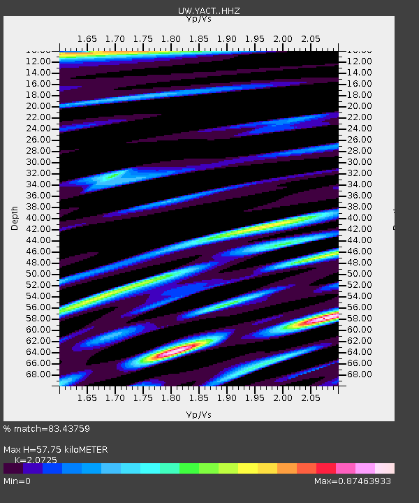
| Estimated Moho Depth: |
57.75 km |
| Estimated Crust Vp/Vs: |
2.07 |
| Assumed Crust Vp: |
6.566 km/s |
| Estimated Crust Vs: |
3.168 km/s |
| Estimated Crust Poisson's Ratio: |
0.35 |
|
| Radial Match: |
83.43759 % |
| Radial Bump: |
400 |
| Transverse Match: |
66.65485 % |
| Transverse Bump: |
400 |
| SOD ConfigId: |
13570011 |
| Insert Time: |
2019-04-30 23:35:47.712 +0000 |
| GWidth: |
2.5 |
| Max Bumps: |
400 |
| Tol: |
0.001 |
|
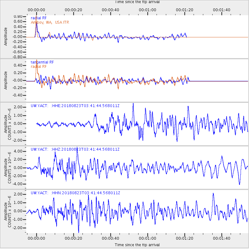
Signal To Noise
| Channel | StoN | STA | LTA |
| UW:YACT: :HHZ:20180823T03:41:44.568011Z | 4.9486732 | 1.0200376E-6 | 2.0612346E-7 |
| UW:YACT: :HHN:20180823T03:41:44.568011Z | 1.7527795 | 4.140332E-7 | 2.3621521E-7 |
| UW:YACT: :HHE:20180823T03:41:44.568011Z | 4.1323905 | 5.9183236E-7 | 1.4321792E-7 |
| Arrivals |
| Ps | 10 SECOND |
| PpPs | 25 SECOND |
| PsPs/PpSs | 35 SECOND |


