You are here: Home > Network List > YO16 - Yukon Observatory Stations List
> Station KOTA YGS, Kotaneelee Airstrip, YK > Earthquake Result Viewer
KOTA YGS, Kotaneelee Airstrip, YK - Earthquake Result Viewer
| Earthquake location: |
Andreanof Islands, Aleutian Is. |
| Earthquake latitude/longitude: |
51.5/-177.9 |
| Earthquake time(UTC): |
2018/08/23 (235) 03:35:15 GMT |
| Earthquake Depth: |
44 km |
| Earthquake Magnitude: |
6.0 Ml |
| Earthquake Catalog/Contributor: |
NEIC PDE/us |
|
| Network: |
YO Yukon Observatory |
| Station: |
KOTA YGS, Kotaneelee Airstrip, YK |
| Lat/Lon: |
60.13 N/124.05 W |
| Elevation: |
386 m |
|
| Distance: |
30.6 deg |
| Az: |
52.472 deg |
| Baz: |
278.063 deg |
| Ray Param: |
0.07922978 |
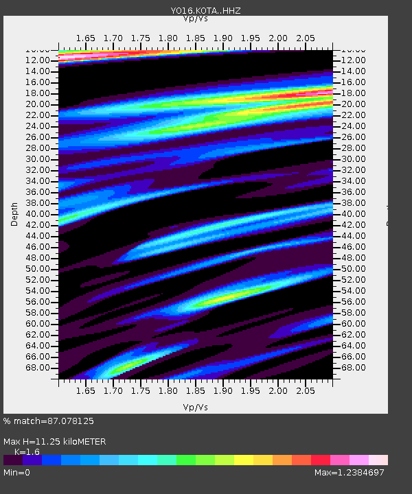
| Estimated Moho Depth: |
11.25 km |
| Estimated Crust Vp/Vs: |
1.60 |
| Assumed Crust Vp: |
6.419 km/s |
| Estimated Crust Vs: |
4.012 km/s |
| Estimated Crust Poisson's Ratio: |
0.18 |
|
| Radial Match: |
87.078125 % |
| Radial Bump: |
355 |
| Transverse Match: |
72.76682 % |
| Transverse Bump: |
400 |
| SOD ConfigId: |
13570011 |
| Insert Time: |
2019-04-30 23:36:28.321 +0000 |
| GWidth: |
2.5 |
| Max Bumps: |
400 |
| Tol: |
0.001 |
|

Signal To Noise
| Channel | StoN | STA | LTA |
| YO:KOTA: :HHZ:20180823T03:40:55.800006Z | 3.3988123 | 5.495829E-7 | 1.6169851E-7 |
| YO:KOTA: :HHN:20180823T03:40:55.800006Z | 1.6230267 | 1.4034406E-7 | 8.647058E-8 |
| YO:KOTA: :HHE:20180823T03:40:55.800006Z | 2.4573805 | 3.9408494E-7 | 1.6036789E-7 |
| Arrivals |
| Ps | 1.1 SECOND |
| PpPs | 4.2 SECOND |
| PsPs/PpSs | 5.3 SECOND |


