You are here: Home > Network List > 5H - Central Virginia and South Carolina seismic monitoring experiment Stations List
> Station ANNI Yanceyville, VA > Earthquake Result Viewer
ANNI Yanceyville, VA - Earthquake Result Viewer
| Earthquake location: |
Peru-Brazil Border Region |
| Earthquake latitude/longitude: |
-11.0/-70.8 |
| Earthquake time(UTC): |
2018/08/24 (236) 09:04:06 GMT |
| Earthquake Depth: |
609 km |
| Earthquake Magnitude: |
7.1 Mww |
| Earthquake Catalog/Contributor: |
NEIC PDE/us |
|
| Network: |
5H Central Virginia and South Carolina seismic monitoring experiment |
| Station: |
ANNI Yanceyville, VA |
| Lat/Lon: |
37.94 N/77.97 W |
| Elevation: |
93 m |
|
| Distance: |
49.2 deg |
| Az: |
352.529 deg |
| Baz: |
170.709 deg |
| Ray Param: |
0.065963075 |
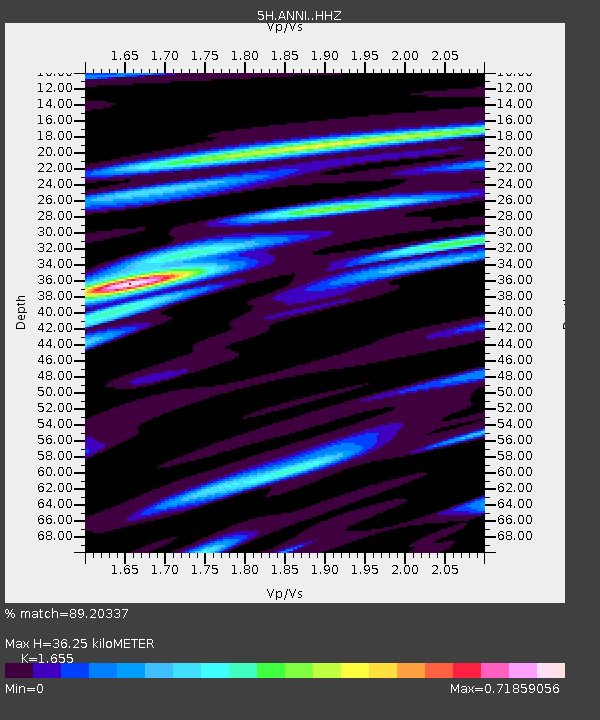
| Estimated Moho Depth: |
36.25 km |
| Estimated Crust Vp/Vs: |
1.65 |
| Assumed Crust Vp: |
6.565 km/s |
| Estimated Crust Vs: |
3.966 km/s |
| Estimated Crust Poisson's Ratio: |
0.21 |
|
| Radial Match: |
89.20337 % |
| Radial Bump: |
322 |
| Transverse Match: |
75.335335 % |
| Transverse Bump: |
400 |
| SOD ConfigId: |
13570011 |
| Insert Time: |
2019-04-30 23:43:22.629 +0000 |
| GWidth: |
2.5 |
| Max Bumps: |
400 |
| Tol: |
0.001 |
|

Signal To Noise
| Channel | StoN | STA | LTA |
| 5H:ANNI: :HHZ:20180824T09:11:30.045015Z | 151.05847 | 1.3561807E-5 | 8.9778524E-8 |
| 5H:ANNI: :HHN:20180824T09:11:30.045015Z | 47.97693 | 7.2846137E-6 | 1.5183576E-7 |
| 5H:ANNI: :HHE:20180824T09:11:30.045015Z | 4.8696613 | 8.5951564E-7 | 1.7650419E-7 |
| Arrivals |
| Ps | 3.8 SECOND |
| PpPs | 14 SECOND |
| PsPs/PpSs | 18 SECOND |


