You are here: Home > Network List > 5H - Central Virginia and South Carolina seismic monitoring experiment Stations List
> Station BEAV Louisa, VA > Earthquake Result Viewer
BEAV Louisa, VA - Earthquake Result Viewer
| Earthquake location: |
Peru-Brazil Border Region |
| Earthquake latitude/longitude: |
-11.0/-70.8 |
| Earthquake time(UTC): |
2018/08/24 (236) 09:04:06 GMT |
| Earthquake Depth: |
609 km |
| Earthquake Magnitude: |
7.1 Mww |
| Earthquake Catalog/Contributor: |
NEIC PDE/us |
|
| Network: |
5H Central Virginia and South Carolina seismic monitoring experiment |
| Station: |
BEAV Louisa, VA |
| Lat/Lon: |
38.00 N/78.00 W |
| Elevation: |
118 m |
|
| Distance: |
49.2 deg |
| Az: |
352.507 deg |
| Baz: |
170.675 deg |
| Ray Param: |
0.0659215 |
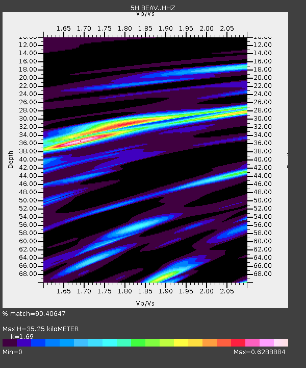
| Estimated Moho Depth: |
35.25 km |
| Estimated Crust Vp/Vs: |
1.69 |
| Assumed Crust Vp: |
6.565 km/s |
| Estimated Crust Vs: |
3.884 km/s |
| Estimated Crust Poisson's Ratio: |
0.23 |
|
| Radial Match: |
90.40647 % |
| Radial Bump: |
375 |
| Transverse Match: |
69.7843 % |
| Transverse Bump: |
400 |
| SOD ConfigId: |
13570011 |
| Insert Time: |
2019-04-30 23:43:23.990 +0000 |
| GWidth: |
2.5 |
| Max Bumps: |
400 |
| Tol: |
0.001 |
|

Signal To Noise
| Channel | StoN | STA | LTA |
| 5H:BEAV: :HHZ:20180824T09:11:30.535005Z | 136.72949 | 1.3787053E-5 | 1.0083452E-7 |
| 5H:BEAV: :HHN:20180824T09:11:30.535005Z | 13.578771 | 8.097457E-6 | 5.963321E-7 |
| 5H:BEAV: :HHE:20180824T09:11:30.535005Z | 3.7645416 | 9.821283E-7 | 2.608892E-7 |
| Arrivals |
| Ps | 3.9 SECOND |
| PpPs | 14 SECOND |
| PsPs/PpSs | 18 SECOND |


