You are here: Home > Network List > 5H - Central Virginia and South Carolina seismic monitoring experiment Stations List
> Station DEBI Ferncliff, VA > Earthquake Result Viewer
DEBI Ferncliff, VA - Earthquake Result Viewer
| Earthquake location: |
Peru-Brazil Border Region |
| Earthquake latitude/longitude: |
-11.0/-70.8 |
| Earthquake time(UTC): |
2018/08/24 (236) 09:04:06 GMT |
| Earthquake Depth: |
609 km |
| Earthquake Magnitude: |
7.1 Mww |
| Earthquake Catalog/Contributor: |
NEIC PDE/us |
|
| Network: |
5H Central Virginia and South Carolina seismic monitoring experiment |
| Station: |
DEBI Ferncliff, VA |
| Lat/Lon: |
37.92 N/78.10 W |
| Elevation: |
137 m |
|
| Distance: |
49.2 deg |
| Az: |
352.388 deg |
| Baz: |
170.536 deg |
| Ray Param: |
0.06596007 |
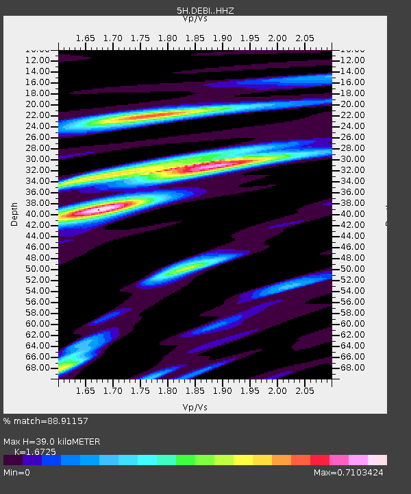
| Estimated Moho Depth: |
39.0 km |
| Estimated Crust Vp/Vs: |
1.67 |
| Assumed Crust Vp: |
6.419 km/s |
| Estimated Crust Vs: |
3.838 km/s |
| Estimated Crust Poisson's Ratio: |
0.22 |
|
| Radial Match: |
88.91157 % |
| Radial Bump: |
328 |
| Transverse Match: |
51.336987 % |
| Transverse Bump: |
400 |
| SOD ConfigId: |
13570011 |
| Insert Time: |
2019-04-30 23:43:24.811 +0000 |
| GWidth: |
2.5 |
| Max Bumps: |
400 |
| Tol: |
0.001 |
|

Signal To Noise
| Channel | StoN | STA | LTA |
| 5H:DEBI: :HHZ:20180824T09:11:30.079988Z | 125.175804 | 1.4047304E-5 | 1.122206E-7 |
| 5H:DEBI: :HHN:20180824T09:11:30.079988Z | 72.20982 | 8.424441E-6 | 1.1666614E-7 |
| 5H:DEBI: :HHE:20180824T09:11:30.079988Z | 1.2978988 | 1.0103578E-6 | 7.784566E-7 |
| Arrivals |
| Ps | 4.3 SECOND |
| PpPs | 15 SECOND |
| PsPs/PpSs | 20 SECOND |


