You are here: Home > Network List > 5H - Central Virginia and South Carolina seismic monitoring experiment Stations List
> Station GOLD Arvonia, VA > Earthquake Result Viewer
GOLD Arvonia, VA - Earthquake Result Viewer
| Earthquake location: |
Peru-Brazil Border Region |
| Earthquake latitude/longitude: |
-11.0/-70.8 |
| Earthquake time(UTC): |
2018/08/24 (236) 09:04:06 GMT |
| Earthquake Depth: |
609 km |
| Earthquake Magnitude: |
7.1 Mww |
| Earthquake Catalog/Contributor: |
NEIC PDE/us |
|
| Network: |
5H Central Virginia and South Carolina seismic monitoring experiment |
| Station: |
GOLD Arvonia, VA |
| Lat/Lon: |
37.68 N/78.37 W |
| Elevation: |
136 m |
|
| Distance: |
49.0 deg |
| Az: |
352.057 deg |
| Baz: |
170.155 deg |
| Ray Param: |
0.06608415 |
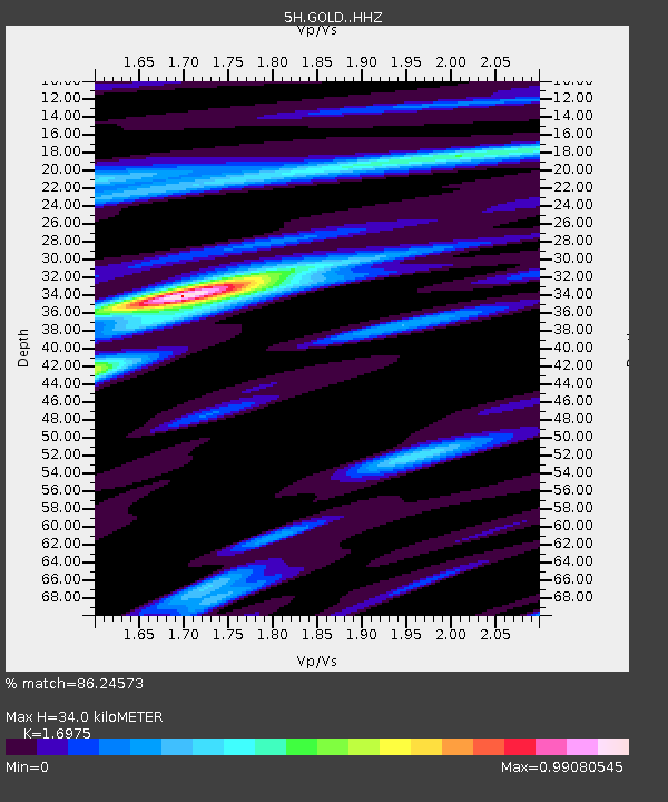
| Estimated Moho Depth: |
34.0 km |
| Estimated Crust Vp/Vs: |
1.70 |
| Assumed Crust Vp: |
6.419 km/s |
| Estimated Crust Vs: |
3.782 km/s |
| Estimated Crust Poisson's Ratio: |
0.23 |
|
| Radial Match: |
86.24573 % |
| Radial Bump: |
297 |
| Transverse Match: |
67.79117 % |
| Transverse Bump: |
400 |
| SOD ConfigId: |
13570011 |
| Insert Time: |
2019-04-30 23:43:27.624 +0000 |
| GWidth: |
2.5 |
| Max Bumps: |
400 |
| Tol: |
0.001 |
|

Signal To Noise
| Channel | StoN | STA | LTA |
| 5H:GOLD: :HHZ:20180824T09:11:28.619996Z | 146.41748 | 1.2916187E-5 | 8.821479E-8 |
| 5H:GOLD: :HHN:20180824T09:11:28.619996Z | 67.1695 | 6.5350678E-6 | 9.7292194E-8 |
| 5H:GOLD: :HHE:20180824T09:11:28.619996Z | 9.915286 | 1.2216908E-6 | 1.2321286E-7 |
| Arrivals |
| Ps | 3.9 SECOND |
| PpPs | 14 SECOND |
| PsPs/PpSs | 17 SECOND |


