You are here: Home > Network List > 5H - Central Virginia and South Carolina seismic monitoring experiment Stations List
> Station GOOD Gooden Farm > Earthquake Result Viewer
GOOD Gooden Farm - Earthquake Result Viewer
| Earthquake location: |
Peru-Brazil Border Region |
| Earthquake latitude/longitude: |
-11.0/-70.8 |
| Earthquake time(UTC): |
2018/08/24 (236) 09:04:06 GMT |
| Earthquake Depth: |
609 km |
| Earthquake Magnitude: |
7.1 Mww |
| Earthquake Catalog/Contributor: |
NEIC PDE/us |
|
| Network: |
5H Central Virginia and South Carolina seismic monitoring experiment |
| Station: |
GOOD Gooden Farm |
| Lat/Lon: |
37.60 N/78.64 W |
| Elevation: |
175 m |
|
| Distance: |
48.9 deg |
| Az: |
351.752 deg |
| Baz: |
169.786 deg |
| Ray Param: |
0.06610954 |
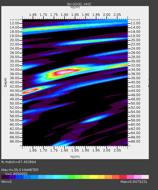
| Estimated Moho Depth: |
35.0 km |
| Estimated Crust Vp/Vs: |
1.81 |
| Assumed Crust Vp: |
6.419 km/s |
| Estimated Crust Vs: |
3.556 km/s |
| Estimated Crust Poisson's Ratio: |
0.28 |
|
| Radial Match: |
87.453964 % |
| Radial Bump: |
400 |
| Transverse Match: |
78.050354 % |
| Transverse Bump: |
400 |
| SOD ConfigId: |
13570011 |
| Insert Time: |
2019-04-30 23:43:28.233 +0000 |
| GWidth: |
2.5 |
| Max Bumps: |
400 |
| Tol: |
0.001 |
|

Signal To Noise
| Channel | StoN | STA | LTA |
| 5H:GOOD: :HHZ:20180824T09:11:28.325013Z | 123.65276 | 1.4026894E-5 | 1.1343777E-7 |
| 5H:GOOD: :HHN:20180824T09:11:28.325013Z | 63.448074 | 7.6051538E-6 | 1.1986421E-7 |
| 5H:GOOD: :HHE:20180824T09:11:28.325013Z | 14.907069 | 1.3218755E-6 | 8.8674405E-8 |
| Arrivals |
| Ps | 4.6 SECOND |
| PpPs | 15 SECOND |
| PsPs/PpSs | 19 SECOND |


