You are here: Home > Network List > 5H - Central Virginia and South Carolina seismic monitoring experiment Stations List
> Station PTTI Yanceyville, VA > Earthquake Result Viewer
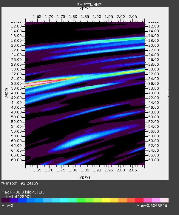
PTTI Yanceyville, VA - Earthquake Result Viewer
| Earthquake location: |
Peru-Brazil Border Region |
| Earthquake latitude/longitude: |
-11.0/-70.8 |
| Earthquake time(UTC): |
2018/08/24 (236) 09:04:06 GMT |
| Earthquake Depth: |
609 km |
| Earthquake Magnitude: |
7.1 Mww |
| Earthquake Catalog/Contributor: |
NEIC PDE/us |
|
| Network: |
5H Central Virginia and South Carolina seismic monitoring experiment |
| Station: |
PTTI Yanceyville, VA |
| Lat/Lon: |
37.94 N/77.99 W |
| Elevation: |
98 m |
|
| Distance: |
49.2 deg |
| Az: |
352.509 deg |
| Baz: |
170.684 deg |
| Ray Param: |
0.06595811 |
| Estimated Moho Depth: |
36.0 km |
| Estimated Crust Vp/Vs: |
1.62 |
| Assumed Crust Vp: |
6.565 km/s |
| Estimated Crust Vs: |
4.046 km/s |
| Estimated Crust Poisson's Ratio: |
0.19 |
|
| Radial Match: |
92.24169 % |
| Radial Bump: |
333 |
| Transverse Match: |
75.3669 % |
| Transverse Bump: |
400 |
| SOD ConfigId: |
13570011 |
| Insert Time: |
2019-04-30 23:43:33.222 +0000 |
| GWidth: |
2.5 |
| Max Bumps: |
400 |
| Tol: |
0.001 |
|

Signal To Noise
| Channel | StoN | STA | LTA |
| 5H:PTTI: :HHZ:20180824T09:11:30.105012Z | 162.92697 | 1.3772998E-5 | 8.45348E-8 |
| 5H:PTTI: :HHN:20180824T09:11:30.105012Z | 87.71445 | 7.371622E-6 | 8.404114E-8 |
| 5H:PTTI: :HHE:20180824T09:11:30.105012Z | 7.4954224 | 7.741585E-7 | 1.0328417E-7 |
| Arrivals |
| Ps | 3.6 SECOND |
| PpPs | 14 SECOND |
| PsPs/PpSs | 17 SECOND |


