You are here: Home > Network List > AF - Africa Array Stations List
> Station POGA Pongola KS2000 earth data Low gain > Earthquake Result Viewer
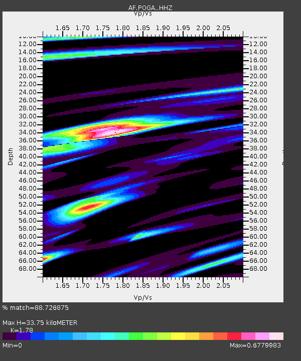
POGA Pongola KS2000 earth data Low gain - Earthquake Result Viewer
| Earthquake location: |
Peru-Brazil Border Region |
| Earthquake latitude/longitude: |
-11.0/-70.8 |
| Earthquake time(UTC): |
2018/08/24 (236) 09:04:06 GMT |
| Earthquake Depth: |
609 km |
| Earthquake Magnitude: |
7.1 Mww |
| Earthquake Catalog/Contributor: |
NEIC PDE/us |
|
| Network: |
AF Africa Array |
| Station: |
POGA Pongola KS2000 earth data Low gain |
| Lat/Lon: |
27.35 S/31.71 E |
| Elevation: |
290 m |
|
| Distance: |
95.9 deg |
| Az: |
119.2 deg |
| Baz: |
254.457 deg |
| Ray Param: |
0.03999407 |
| Estimated Moho Depth: |
33.75 km |
| Estimated Crust Vp/Vs: |
1.78 |
| Assumed Crust Vp: |
6.65 km/s |
| Estimated Crust Vs: |
3.736 km/s |
| Estimated Crust Poisson's Ratio: |
0.27 |
|
| Radial Match: |
88.726875 % |
| Radial Bump: |
321 |
| Transverse Match: |
76.52238 % |
| Transverse Bump: |
400 |
| SOD ConfigId: |
13570011 |
| Insert Time: |
2019-04-30 23:43:47.913 +0000 |
| GWidth: |
2.5 |
| Max Bumps: |
400 |
| Tol: |
0.001 |
|

Signal To Noise
| Channel | StoN | STA | LTA |
| AF:POGA: :HHZ:20180824T09:15:57.829988Z | 28.942814 | 8.138613E-6 | 2.8119632E-7 |
| AF:POGA: :HHN:20180824T09:15:57.829988Z | 4.181073 | 9.1020144E-7 | 2.1769564E-7 |
| AF:POGA: :HHE:20180824T09:15:57.829988Z | 10.693758 | 2.884287E-6 | 2.6971688E-7 |
| Arrivals |
| Ps | 4.0 SECOND |
| PpPs | 14 SECOND |
| PsPs/PpSs | 18 SECOND |


