You are here: Home > Network List > AV - Alaska Volcano Observatory Stations List
> Station RDT Redoubt, Alaska > Earthquake Result Viewer
RDT Redoubt, Alaska - Earthquake Result Viewer
| Earthquake location: |
Peru-Brazil Border Region |
| Earthquake latitude/longitude: |
-11.0/-70.8 |
| Earthquake time(UTC): |
2018/08/24 (236) 09:04:06 GMT |
| Earthquake Depth: |
609 km |
| Earthquake Magnitude: |
7.1 Mww |
| Earthquake Catalog/Contributor: |
NEIC PDE/us |
|
| Network: |
AV Alaska Volcano Observatory |
| Station: |
RDT Redoubt, Alaska |
| Lat/Lon: |
60.57 N/152.41 W |
| Elevation: |
930 m |
|
| Distance: |
95.4 deg |
| Az: |
330.612 deg |
| Baz: |
102.698 deg |
| Ray Param: |
0.04013376 |
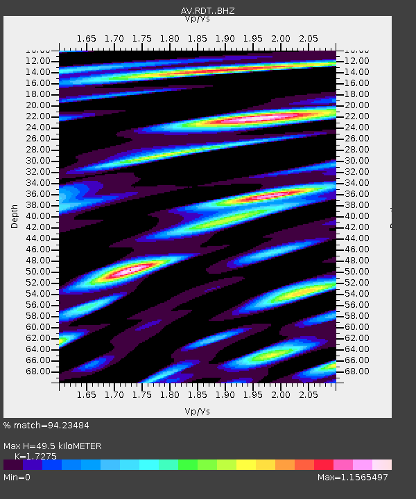
| Estimated Moho Depth: |
49.5 km |
| Estimated Crust Vp/Vs: |
1.73 |
| Assumed Crust Vp: |
6.566 km/s |
| Estimated Crust Vs: |
3.801 km/s |
| Estimated Crust Poisson's Ratio: |
0.25 |
|
| Radial Match: |
94.23484 % |
| Radial Bump: |
400 |
| Transverse Match: |
94.241875 % |
| Transverse Bump: |
400 |
| SOD ConfigId: |
13570011 |
| Insert Time: |
2019-04-30 23:45:15.679 +0000 |
| GWidth: |
2.5 |
| Max Bumps: |
400 |
| Tol: |
0.001 |
|

Signal To Noise
| Channel | StoN | STA | LTA |
| AV:RDT: :BHZ:20180824T09:15:55.839021Z | 63.72399 | 2.6167659E-6 | 4.106406E-8 |
| AV:RDT: :BHN:20180824T09:15:55.839021Z | 10.076336 | 6.5540604E-7 | 6.5044084E-8 |
| AV:RDT: :BHE:20180824T09:15:55.839021Z | 21.986912 | 1.1611377E-6 | 5.28104E-8 |
| Arrivals |
| Ps | 5.6 SECOND |
| PpPs | 20 SECOND |
| PsPs/PpSs | 26 SECOND |


