You are here: Home > Network List > CI - Caltech Regional Seismic Network Stations List
> Station CIA CIA, Avalon Catalina Island, CA, USA > Earthquake Result Viewer
CIA CIA, Avalon Catalina Island, CA, USA - Earthquake Result Viewer
| Earthquake location: |
Peru-Brazil Border Region |
| Earthquake latitude/longitude: |
-11.0/-70.8 |
| Earthquake time(UTC): |
2018/08/24 (236) 09:04:06 GMT |
| Earthquake Depth: |
609 km |
| Earthquake Magnitude: |
7.1 Mww |
| Earthquake Catalog/Contributor: |
NEIC PDE/us |
|
| Network: |
CI Caltech Regional Seismic Network |
| Station: |
CIA CIA, Avalon Catalina Island, CA, USA |
| Lat/Lon: |
33.40 N/118.41 W |
| Elevation: |
467 m |
|
| Distance: |
63.3 deg |
| Az: |
316.25 deg |
| Baz: |
125.753 deg |
| Ray Param: |
0.057323158 |
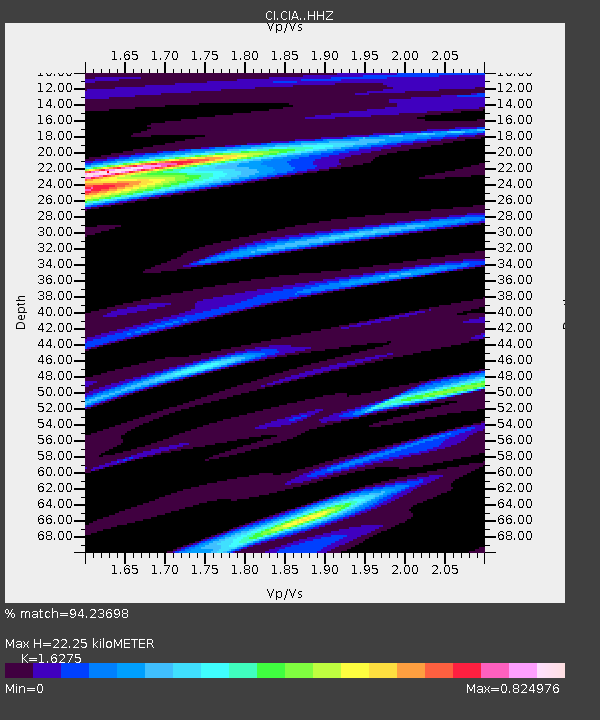
| Estimated Moho Depth: |
22.25 km |
| Estimated Crust Vp/Vs: |
1.63 |
| Assumed Crust Vp: |
6.048 km/s |
| Estimated Crust Vs: |
3.716 km/s |
| Estimated Crust Poisson's Ratio: |
0.20 |
|
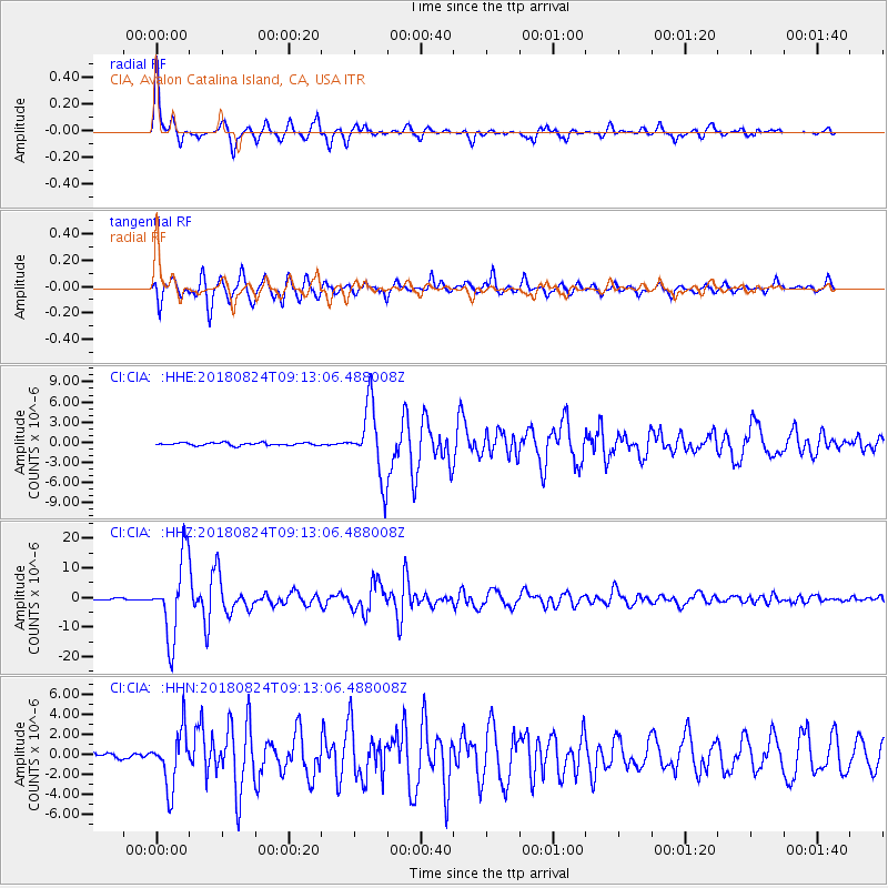
| Radial Match: |
94.23698 % |
| Radial Bump: |
400 |
| Transverse Match: |
89.685 % |
| Transverse Bump: |
400 |
| SOD ConfigId: |
13570011 |
| Insert Time: |
2019-04-30 23:46:50.638 +0000 |
| GWidth: |
2.5 |
| Max Bumps: |
400 |
| Tol: |
0.001 |
|
Signal To Noise
| Channel | StoN | STA | LTA |
| CI:CIA: :HHZ:20180824T09:13:06.488008Z | 43.85822 | 1.34348975E-5 | 3.0632566E-7 |
| CI:CIA: :HHN:20180824T09:13:06.488008Z | 12.314683 | 2.7436517E-6 | 2.2279515E-7 |
| CI:CIA: :HHE:20180824T09:13:06.488008Z | 27.342201 | 5.263698E-6 | 1.9251186E-7 |
| Arrivals |
| Ps | 2.4 SECOND |
| PpPs | 9.3 SECOND |
| PsPs/PpSs | 12 SECOND |


