You are here: Home > Network List > CI - Caltech Regional Seismic Network Stations List
> Station MPM Manuel Prospect Mine, California, USA > Earthquake Result Viewer
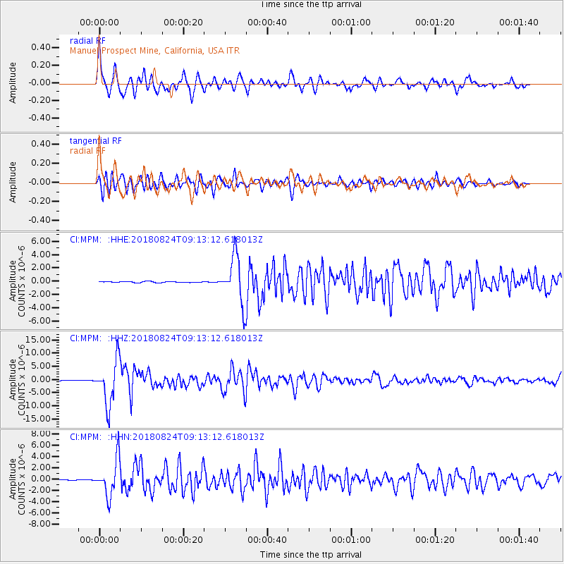
MPM Manuel Prospect Mine, California, USA - Earthquake Result Viewer
*The percent match for this event was below the threshold and hence no stack was calculated.
| Earthquake location: |
Peru-Brazil Border Region |
| Earthquake latitude/longitude: |
-11.0/-70.8 |
| Earthquake time(UTC): |
2018/08/24 (236) 09:04:06 GMT |
| Earthquake Depth: |
609 km |
| Earthquake Magnitude: |
7.1 Mww |
| Earthquake Catalog/Contributor: |
NEIC PDE/us |
|
| Network: |
CI Caltech Regional Seismic Network |
| Station: |
MPM Manuel Prospect Mine, California, USA |
| Lat/Lon: |
36.06 N/117.49 W |
| Elevation: |
185 m |
|
| Distance: |
64.3 deg |
| Az: |
319.127 deg |
| Baz: |
127.549 deg |
| Ray Param: |
$rayparam |
*The percent match for this event was below the threshold and hence was not used in the summary stack. |
|
| Radial Match: |
77.8658 % |
| Radial Bump: |
400 |
| Transverse Match: |
79.76224 % |
| Transverse Bump: |
400 |
| SOD ConfigId: |
13570011 |
| Insert Time: |
2019-04-30 23:47:12.060 +0000 |
| GWidth: |
2.5 |
| Max Bumps: |
400 |
| Tol: |
0.001 |
|
Signal To Noise
| Channel | StoN | STA | LTA |
| CI:MPM: :HHZ:20180824T09:13:12.618013Z | 152.96477 | 8.536513E-6 | 5.5807057E-8 |
| CI:MPM: :HHN:20180824T09:13:12.618013Z | 44.944195 | 3.3273861E-6 | 7.403372E-8 |
| CI:MPM: :HHE:20180824T09:13:12.618013Z | 46.020996 | 3.6900003E-6 | 8.01808E-8 |
| Arrivals |
| Ps | |
| PpPs | |
| PsPs/PpSs | |


