You are here: Home > Network List > CI - Caltech Regional Seismic Network Stations List
> Station SDD Saddleback, Mission Viejo, CA, USA > Earthquake Result Viewer
SDD Saddleback, Mission Viejo, CA, USA - Earthquake Result Viewer
| Earthquake location: |
Peru-Brazil Border Region |
| Earthquake latitude/longitude: |
-11.0/-70.8 |
| Earthquake time(UTC): |
2018/08/24 (236) 09:04:06 GMT |
| Earthquake Depth: |
609 km |
| Earthquake Magnitude: |
7.1 Mww |
| Earthquake Catalog/Contributor: |
NEIC PDE/us |
|
| Network: |
CI Caltech Regional Seismic Network |
| Station: |
SDD Saddleback, Mission Viejo, CA, USA |
| Lat/Lon: |
33.55 N/117.66 W |
| Elevation: |
120 m |
|
| Distance: |
62.9 deg |
| Az: |
316.802 deg |
| Baz: |
126.416 deg |
| Ray Param: |
0.05758673 |
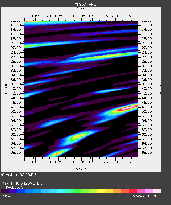
| Estimated Moho Depth: |
48.0 km |
| Estimated Crust Vp/Vs: |
2.06 |
| Assumed Crust Vp: |
6.264 km/s |
| Estimated Crust Vs: |
3.044 km/s |
| Estimated Crust Poisson's Ratio: |
0.35 |
|
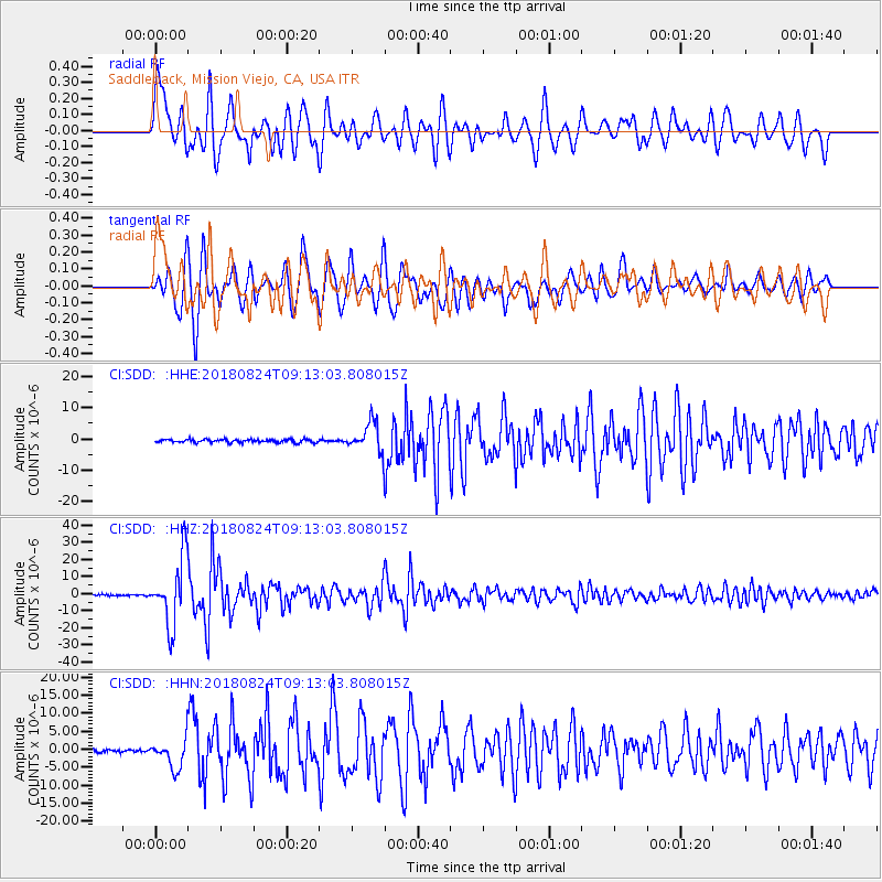
| Radial Match: |
83.93615 % |
| Radial Bump: |
400 |
| Transverse Match: |
82.97195 % |
| Transverse Bump: |
400 |
| SOD ConfigId: |
13570011 |
| Insert Time: |
2019-04-30 23:47:22.892 +0000 |
| GWidth: |
2.5 |
| Max Bumps: |
400 |
| Tol: |
0.001 |
|
Signal To Noise
| Channel | StoN | STA | LTA |
| CI:SDD: :HHZ:20180824T09:13:03.808015Z | 49.27184 | 1.9392277E-5 | 3.935773E-7 |
| CI:SDD: :HHN:20180824T09:13:03.808015Z | 8.7439165 | 3.9973393E-6 | 4.5715663E-7 |
| CI:SDD: :HHE:20180824T09:13:03.808015Z | 9.410458 | 4.6088326E-6 | 4.897565E-7 |
| Arrivals |
| Ps | 8.4 SECOND |
| PpPs | 23 SECOND |
| PsPs/PpSs | 31 SECOND |


