You are here: Home > Network List > CN - Canadian National Seismograph Network Stations List
> Station RES Resolute, NU, CA > Earthquake Result Viewer
RES Resolute, NU, CA - Earthquake Result Viewer
| Earthquake location: |
Peru-Brazil Border Region |
| Earthquake latitude/longitude: |
-11.0/-70.8 |
| Earthquake time(UTC): |
2018/08/24 (236) 09:04:06 GMT |
| Earthquake Depth: |
609 km |
| Earthquake Magnitude: |
7.1 Mww |
| Earthquake Catalog/Contributor: |
NEIC PDE/us |
|
| Network: |
CN Canadian National Seismograph Network |
| Station: |
RES Resolute, NU, CA |
| Lat/Lon: |
74.69 N/94.90 W |
| Elevation: |
19 m |
|
| Distance: |
86.9 deg |
| Az: |
353.767 deg |
| Baz: |
156.35 deg |
| Ray Param: |
0.041975193 |
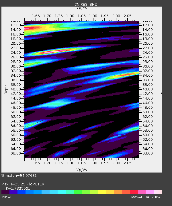
| Estimated Moho Depth: |
23.25 km |
| Estimated Crust Vp/Vs: |
1.73 |
| Assumed Crust Vp: |
6.367 km/s |
| Estimated Crust Vs: |
3.675 km/s |
| Estimated Crust Poisson's Ratio: |
0.25 |
|
| Radial Match: |
94.97631 % |
| Radial Bump: |
400 |
| Transverse Match: |
94.865906 % |
| Transverse Bump: |
400 |
| SOD ConfigId: |
13570011 |
| Insert Time: |
2019-04-30 23:48:11.500 +0000 |
| GWidth: |
2.5 |
| Max Bumps: |
400 |
| Tol: |
0.001 |
|

Signal To Noise
| Channel | StoN | STA | LTA |
| CN:RES: :BHZ:20180824T09:15:16.725007Z | 55.111206 | 1.5983698E-5 | 2.900263E-7 |
| CN:RES: :BHN:20180824T09:15:16.725007Z | 23.513203 | 4.9899277E-6 | 2.1221811E-7 |
| CN:RES: :BHE:20180824T09:15:16.725007Z | 7.522553 | 1.2124774E-6 | 1.6117899E-7 |
| Arrivals |
| Ps | 2.7 SECOND |
| PpPs | 9.8 SECOND |
| PsPs/PpSs | 13 SECOND |


