You are here: Home > Network List > GE - GEOFON Stations List
> Station SNAA GEOFON/AWI Station Sanae, Antarctica > Earthquake Result Viewer
SNAA GEOFON/AWI Station Sanae, Antarctica - Earthquake Result Viewer
| Earthquake location: |
Peru-Brazil Border Region |
| Earthquake latitude/longitude: |
-11.0/-70.8 |
| Earthquake time(UTC): |
2018/08/24 (236) 09:04:06 GMT |
| Earthquake Depth: |
609 km |
| Earthquake Magnitude: |
7.1 Mww |
| Earthquake Catalog/Contributor: |
NEIC PDE/us |
|
| Network: |
GE GEOFON |
| Station: |
SNAA GEOFON/AWI Station Sanae, Antarctica |
| Lat/Lon: |
71.67 S/2.84 W |
| Elevation: |
846 m |
|
| Distance: |
72.7 deg |
| Az: |
162.112 deg |
| Baz: |
287.616 deg |
| Ray Param: |
0.05141297 |
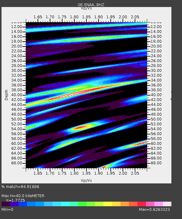
| Estimated Moho Depth: |
40.0 km |
| Estimated Crust Vp/Vs: |
1.77 |
| Assumed Crust Vp: |
6.43 km/s |
| Estimated Crust Vs: |
3.628 km/s |
| Estimated Crust Poisson's Ratio: |
0.27 |
|
| Radial Match: |
94.91686 % |
| Radial Bump: |
292 |
| Transverse Match: |
93.14621 % |
| Transverse Bump: |
370 |
| SOD ConfigId: |
13570011 |
| Insert Time: |
2019-04-30 23:49:01.150 +0000 |
| GWidth: |
2.5 |
| Max Bumps: |
400 |
| Tol: |
0.001 |
|

Signal To Noise
| Channel | StoN | STA | LTA |
| GE:SNAA: :BHZ:20180824T09:14:03.360994Z | 343.91696 | 0.0020487886 | 5.957219E-6 |
| GE:SNAA: :BHN:20180824T09:14:03.360994Z | 46.499855 | 3.2897614E-4 | 7.074778E-6 |
| GE:SNAA: :BHE:20180824T09:14:03.360994Z | 88.040054 | 6.850551E-4 | 7.781176E-6 |
| Arrivals |
| Ps | 5.0 SECOND |
| PpPs | 17 SECOND |
| PsPs/PpSs | 22 SECOND |


