You are here: Home > Network List > KP - Korea Polar Seismic Network Stations List
> Station UPNV Upernavik, Greenland > Earthquake Result Viewer
UPNV Upernavik, Greenland - Earthquake Result Viewer
| Earthquake location: |
Peru-Brazil Border Region |
| Earthquake latitude/longitude: |
-11.0/-70.8 |
| Earthquake time(UTC): |
2018/08/24 (236) 09:04:06 GMT |
| Earthquake Depth: |
609 km |
| Earthquake Magnitude: |
7.1 Mww |
| Earthquake Catalog/Contributor: |
NEIC PDE/us |
|
| Network: |
KP Korea Polar Seismic Network |
| Station: |
UPNV Upernavik, Greenland |
| Lat/Lon: |
72.78 N/56.14 W |
| Elevation: |
38 m |
|
| Distance: |
84.2 deg |
| Az: |
4.35 deg |
| Baz: |
194.479 deg |
| Ray Param: |
0.043843225 |
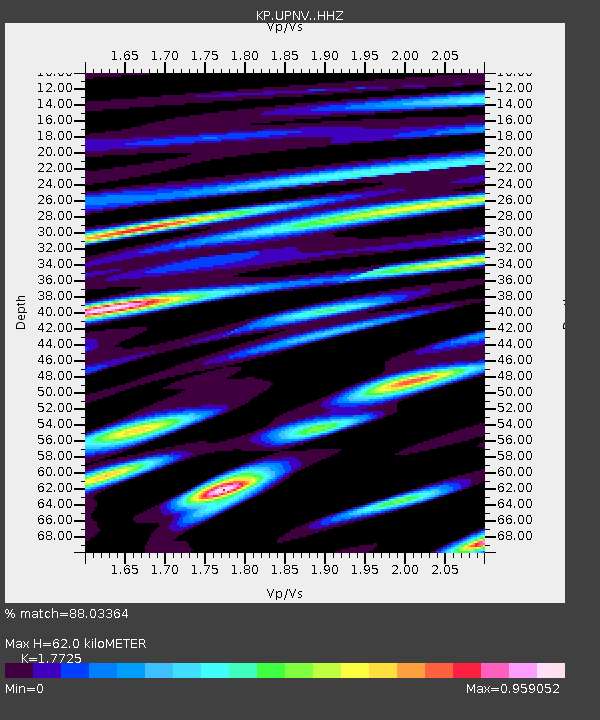
| Estimated Moho Depth: |
62.0 km |
| Estimated Crust Vp/Vs: |
1.77 |
| Assumed Crust Vp: |
6.307 km/s |
| Estimated Crust Vs: |
3.558 km/s |
| Estimated Crust Poisson's Ratio: |
0.27 |
|
| Radial Match: |
88.03364 % |
| Radial Bump: |
400 |
| Transverse Match: |
81.81729 % |
| Transverse Bump: |
400 |
| SOD ConfigId: |
13570011 |
| Insert Time: |
2019-04-30 23:49:36.611 +0000 |
| GWidth: |
2.5 |
| Max Bumps: |
400 |
| Tol: |
0.001 |
|

Signal To Noise
| Channel | StoN | STA | LTA |
| KP:UPNV: :HHZ:20180824T09:15:03.999971Z | 55.56407 | 1.3049435E-5 | 2.3485384E-7 |
| KP:UPNV: :HHN:20180824T09:15:03.999971Z | 20.870895 | 4.135174E-6 | 1.9813112E-7 |
| KP:UPNV: :HHE:20180824T09:15:03.999971Z | 3.260147 | 8.4921703E-7 | 2.6048426E-7 |
| Arrivals |
| Ps | 7.8 SECOND |
| PpPs | 27 SECOND |
| PsPs/PpSs | 34 SECOND |


