You are here: Home > Network List > LD - Lamont-Doherty Cooperative Seismographic Network Stations List
> Station WUPA West Chester University of Pennsylvania > Earthquake Result Viewer
WUPA West Chester University of Pennsylvania - Earthquake Result Viewer

| Earthquake location: |
Peru-Brazil Border Region |
| Earthquake latitude/longitude: |
-11.0/-70.8 |
| Earthquake time(UTC): |
2018/08/24 (236) 09:04:06 GMT |
| Earthquake Depth: |
609 km |
| Earthquake Magnitude: |
7.1 Mww |
| Earthquake Catalog/Contributor: |
NEIC PDE/us |
|
| Network: |
LD Lamont-Doherty Cooperative Seismographic Network |
| Station: |
WUPA West Chester University of Pennsylvania |
| Lat/Lon: |
39.93 N/75.61 W |
| Elevation: |
86 m |
|
| Distance: |
50.9 deg |
| Az: |
355.256 deg |
| Baz: |
173.938 deg |
| Ray Param: |
0.0649137 |
| Estimated Moho Depth: |
20.5 km |
| Estimated Crust Vp/Vs: |
2.10 |
| Assumed Crust Vp: |
6.287 km/s |
| Estimated Crust Vs: |
2.998 km/s |
| Estimated Crust Poisson's Ratio: |
0.35 |
|
| Radial Match: |
90.8011 % |
| Radial Bump: |
375 |
| Transverse Match: |
70.09524 % |
| Transverse Bump: |
400 |
| SOD ConfigId: |
13570011 |
| Insert Time: |
2019-04-30 23:50:03.204 +0000 |
| GWidth: |
2.5 |
| Max Bumps: |
400 |
| Tol: |
0.001 |
|
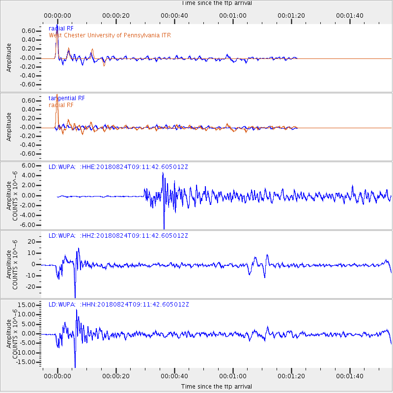
Signal To Noise
| Channel | StoN | STA | LTA |
| LD:WUPA: :HHZ:20180824T09:11:42.605012Z | 65.63233 | 5.3257254E-6 | 8.114485E-8 |
| LD:WUPA: :HHN:20180824T09:11:42.605012Z | 49.9117 | 3.2390442E-6 | 6.489548E-8 |
| LD:WUPA: :HHE:20180824T09:11:42.605012Z | 14.58163 | 8.7147714E-7 | 5.976541E-8 |
| Arrivals |
| Ps | 3.7 SECOND |
| PpPs | 9.7 SECOND |
| PsPs/PpSs | 13 SECOND |


