You are here: Home > Network List > MB - Montana Regional Seismic Network Stations List
> Station LDM Little Jackson Creek seismic vault > Earthquake Result Viewer
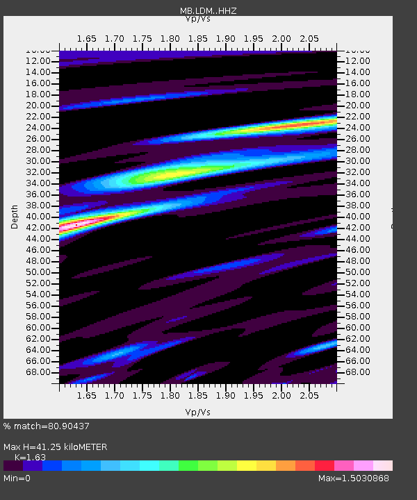
LDM Little Jackson Creek seismic vault - Earthquake Result Viewer
| Earthquake location: |
Peru-Brazil Border Region |
| Earthquake latitude/longitude: |
-11.0/-70.8 |
| Earthquake time(UTC): |
2018/08/24 (236) 09:04:06 GMT |
| Earthquake Depth: |
609 km |
| Earthquake Magnitude: |
7.1 Mww |
| Earthquake Catalog/Contributor: |
NEIC PDE/us |
|
| Network: |
MB Montana Regional Seismic Network |
| Station: |
LDM Little Jackson Creek seismic vault |
| Lat/Lon: |
48.45 N/115.32 W |
| Elevation: |
840 m |
|
| Distance: |
71.1 deg |
| Az: |
330.445 deg |
| Baz: |
133.331 deg |
| Ray Param: |
0.052450318 |
| Estimated Moho Depth: |
41.25 km |
| Estimated Crust Vp/Vs: |
1.63 |
| Assumed Crust Vp: |
6.622 km/s |
| Estimated Crust Vs: |
4.063 km/s |
| Estimated Crust Poisson's Ratio: |
0.20 |
|
| Radial Match: |
80.90437 % |
| Radial Bump: |
400 |
| Transverse Match: |
87.49042 % |
| Transverse Bump: |
400 |
| SOD ConfigId: |
13570011 |
| Insert Time: |
2019-04-30 23:50:07.826 +0000 |
| GWidth: |
2.5 |
| Max Bumps: |
400 |
| Tol: |
0.001 |
|

Signal To Noise
| Channel | StoN | STA | LTA |
| MB:LDM: :HHZ:20180824T09:13:53.939973Z | 247.79391 | 7.464227E-11 | 3.012272E-13 |
| MB:LDM: :HHN:20180824T09:13:53.939973Z | 71.7213 | 1.23502744E-11 | 1.7219815E-13 |
| MB:LDM: :HHE:20180824T09:13:53.939973Z | 140.45871 | 3.313205E-11 | 2.358846E-13 |
| Arrivals |
| Ps | 4.1 SECOND |
| PpPs | 16 SECOND |
| PsPs/PpSs | 20 SECOND |


