You are here: Home > Network List > N4 - Central and EAstern US Network Stations List
> Station 060A Indiantown, FL, USA > Earthquake Result Viewer
060A Indiantown, FL, USA - Earthquake Result Viewer
| Earthquake location: |
Peru-Brazil Border Region |
| Earthquake latitude/longitude: |
-11.0/-70.8 |
| Earthquake time(UTC): |
2018/08/24 (236) 09:04:06 GMT |
| Earthquake Depth: |
609 km |
| Earthquake Magnitude: |
7.1 Mww |
| Earthquake Catalog/Contributor: |
NEIC PDE/us |
|
| Network: |
N4 Central and EAstern US Network |
| Station: |
060A Indiantown, FL, USA |
| Lat/Lon: |
27.04 N/80.36 W |
| Elevation: |
9.0 m |
|
| Distance: |
39.0 deg |
| Az: |
346.398 deg |
| Baz: |
164.998 deg |
| Ray Param: |
0.0720545 |
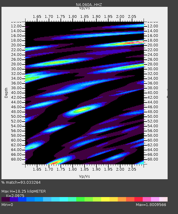
| Estimated Moho Depth: |
18.25 km |
| Estimated Crust Vp/Vs: |
2.10 |
| Assumed Crust Vp: |
6.347 km/s |
| Estimated Crust Vs: |
3.026 km/s |
| Estimated Crust Poisson's Ratio: |
0.35 |
|
| Radial Match: |
93.033264 % |
| Radial Bump: |
322 |
| Transverse Match: |
79.99287 % |
| Transverse Bump: |
400 |
| SOD ConfigId: |
13570011 |
| Insert Time: |
2019-04-30 23:50:19.422 +0000 |
| GWidth: |
2.5 |
| Max Bumps: |
400 |
| Tol: |
0.001 |
|

Signal To Noise
| Channel | StoN | STA | LTA |
| N4:060A: :HHZ:20180824T09:10:11.850007Z | 144.32312 | 2.7716196E-5 | 1.9204266E-7 |
| N4:060A: :HHN:20180824T09:10:11.850007Z | 42.332294 | 1.7475968E-5 | 4.1282829E-7 |
| N4:060A: :HHE:20180824T09:10:11.850007Z | 17.327093 | 5.1364036E-6 | 2.964377E-7 |
| Arrivals |
| Ps | 3.3 SECOND |
| PpPs | 8.4 SECOND |
| PsPs/PpSs | 12 SECOND |


