You are here: Home > Network List > TA - USArray Transportable Network (new EarthScope stations) Stations List
> Station S19A Harvey Farm, Monticello, UT, USA > Earthquake Result Viewer
S19A Harvey Farm, Monticello, UT, USA - Earthquake Result Viewer
| Earthquake location: |
Windward Islands |
| Earthquake latitude/longitude: |
15.0/-61.3 |
| Earthquake time(UTC): |
2007/11/29 (333) 19:00:19 GMT |
| Earthquake Depth: |
148 km |
| Earthquake Magnitude: |
6.9 MB, 7.4 MW, 7.4 MW |
| Earthquake Catalog/Contributor: |
WHDF/NEIC |
|
| Network: |
TA USArray Transportable Network (new EarthScope stations) |
| Station: |
S19A Harvey Farm, Monticello, UT, USA |
| Lat/Lon: |
37.75 N/109.14 W |
| Elevation: |
2059 m |
|
| Distance: |
47.9 deg |
| Az: |
307.592 deg |
| Baz: |
104.969 deg |
| Ray Param: |
0.06917859 |
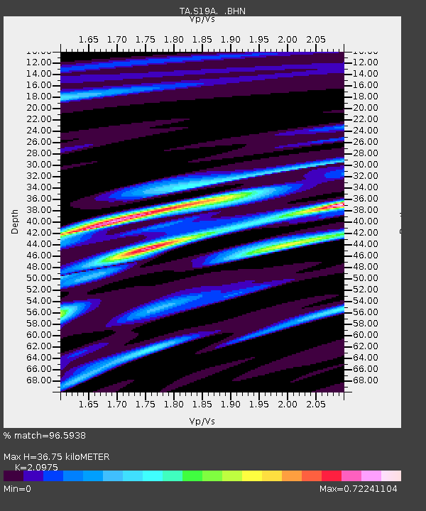
| Estimated Moho Depth: |
36.75 km |
| Estimated Crust Vp/Vs: |
2.10 |
| Assumed Crust Vp: |
6.476 km/s |
| Estimated Crust Vs: |
3.087 km/s |
| Estimated Crust Poisson's Ratio: |
0.35 |
|
| Radial Match: |
96.5938 % |
| Radial Bump: |
316 |
| Transverse Match: |
86.47226 % |
| Transverse Bump: |
400 |
| SOD ConfigId: |
2564 |
| Insert Time: |
2010-03-06 14:45:45.987 +0000 |
| GWidth: |
2.5 |
| Max Bumps: |
400 |
| Tol: |
0.001 |
|

Signal To Noise
| Channel | StoN | STA | LTA |
| TA:S19A: :BHN:20071129T19:08:12.400Z | 7.0046496 | 1.4989781E-6 | 2.1399758E-7 |
| TA:S19A: :BHE:20071129T19:08:12.400Z | 20.610209 | 5.388749E-6 | 2.6146017E-7 |
| TA:S19A: :BHZ:20071129T19:08:12.400Z | 35.728615 | 1.2136121E-5 | 3.3967513E-7 |
| Arrivals |
| Ps | 6.6 SECOND |
| PpPs | 17 SECOND |
| PsPs/PpSs | 23 SECOND |


