You are here: Home > Network List > N4 - Central and EAstern US Network Stations List
> Station D62A Allapoint, Allagash, ME, USA > Earthquake Result Viewer
D62A Allapoint, Allagash, ME, USA - Earthquake Result Viewer
| Earthquake location: |
Peru-Brazil Border Region |
| Earthquake latitude/longitude: |
-11.0/-70.8 |
| Earthquake time(UTC): |
2018/08/24 (236) 09:04:06 GMT |
| Earthquake Depth: |
609 km |
| Earthquake Magnitude: |
7.1 Mww |
| Earthquake Catalog/Contributor: |
NEIC PDE/us |
|
| Network: |
N4 Central and EAstern US Network |
| Station: |
D62A Allapoint, Allagash, ME, USA |
| Lat/Lon: |
47.08 N/69.05 W |
| Elevation: |
189 m |
|
| Distance: |
57.9 deg |
| Az: |
1.426 deg |
| Baz: |
182.048 deg |
| Ray Param: |
0.060652643 |
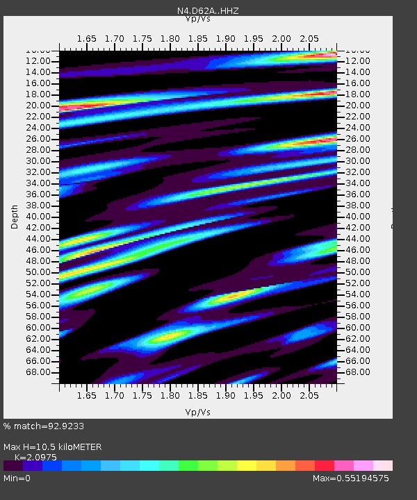
| Estimated Moho Depth: |
10.5 km |
| Estimated Crust Vp/Vs: |
2.10 |
| Assumed Crust Vp: |
6.419 km/s |
| Estimated Crust Vs: |
3.06 km/s |
| Estimated Crust Poisson's Ratio: |
0.35 |
|
| Radial Match: |
92.9233 % |
| Radial Bump: |
282 |
| Transverse Match: |
84.26097 % |
| Transverse Bump: |
367 |
| SOD ConfigId: |
13570011 |
| Insert Time: |
2019-04-30 23:50:34.636 +0000 |
| GWidth: |
2.5 |
| Max Bumps: |
400 |
| Tol: |
0.001 |
|

Signal To Noise
| Channel | StoN | STA | LTA |
| N4:D62A: :HHZ:20180824T09:12:31.139985Z | 117.273445 | 1.755079E-5 | 1.4965698E-7 |
| N4:D62A: :HHN:20180824T09:12:31.139985Z | 52.834755 | 8.364641E-6 | 1.5831702E-7 |
| N4:D62A: :HHE:20180824T09:12:31.139985Z | 16.782452 | 2.918476E-6 | 1.7390045E-7 |
| Arrivals |
| Ps | 1.9 SECOND |
| PpPs | 4.9 SECOND |
| PsPs/PpSs | 6.7 SECOND |


