You are here: Home > Network List > N4 - Central and EAstern US Network Stations List
> Station E63A Oxbow, ME, USA > Earthquake Result Viewer
E63A Oxbow, ME, USA - Earthquake Result Viewer
| Earthquake location: |
Peru-Brazil Border Region |
| Earthquake latitude/longitude: |
-11.0/-70.8 |
| Earthquake time(UTC): |
2018/08/24 (236) 09:04:06 GMT |
| Earthquake Depth: |
609 km |
| Earthquake Magnitude: |
7.1 Mww |
| Earthquake Catalog/Contributor: |
NEIC PDE/us |
|
| Network: |
N4 Central and EAstern US Network |
| Station: |
E63A Oxbow, ME, USA |
| Lat/Lon: |
46.42 N/68.46 W |
| Elevation: |
238 m |
|
| Distance: |
57.2 deg |
| Az: |
1.937 deg |
| Baz: |
182.749 deg |
| Ray Param: |
0.061040826 |
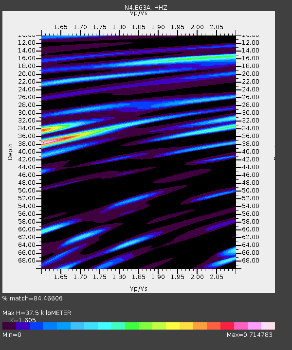
| Estimated Moho Depth: |
37.5 km |
| Estimated Crust Vp/Vs: |
1.61 |
| Assumed Crust Vp: |
6.419 km/s |
| Estimated Crust Vs: |
4.0 km/s |
| Estimated Crust Poisson's Ratio: |
0.18 |
|
| Radial Match: |
84.46606 % |
| Radial Bump: |
400 |
| Transverse Match: |
76.615746 % |
| Transverse Bump: |
400 |
| SOD ConfigId: |
13570011 |
| Insert Time: |
2019-04-30 23:50:38.043 +0000 |
| GWidth: |
2.5 |
| Max Bumps: |
400 |
| Tol: |
0.001 |
|

Signal To Noise
| Channel | StoN | STA | LTA |
| N4:E63A: :HHZ:20180824T09:12:26.809999Z | 54.466007 | 1.4261999E-5 | 2.618514E-7 |
| N4:E63A: :HHN:20180824T09:12:26.809999Z | 23.716969 | 5.269352E-6 | 2.2217647E-7 |
| N4:E63A: :HHE:20180824T09:12:26.809999Z | 9.848201 | 1.2955464E-6 | 1.3155157E-7 |
| Arrivals |
| Ps | 3.7 SECOND |
| PpPs | 14 SECOND |
| PsPs/PpSs | 18 SECOND |


