You are here: Home > Network List > N4 - Central and EAstern US Network Stations List
> Station F33B 5 Mile Ranch, Herman, MN, USA > Earthquake Result Viewer
F33B 5 Mile Ranch, Herman, MN, USA - Earthquake Result Viewer
| Earthquake location: |
Peru-Brazil Border Region |
| Earthquake latitude/longitude: |
-11.0/-70.8 |
| Earthquake time(UTC): |
2018/08/24 (236) 09:04:06 GMT |
| Earthquake Depth: |
609 km |
| Earthquake Magnitude: |
7.1 Mww |
| Earthquake Catalog/Contributor: |
NEIC PDE/us |
|
| Network: |
N4 Central and EAstern US Network |
| Station: |
F33B 5 Mile Ranch, Herman, MN, USA |
| Lat/Lon: |
45.84 N/96.29 W |
| Elevation: |
314 m |
|
| Distance: |
61.1 deg |
| Az: |
339.909 deg |
| Baz: |
151.157 deg |
| Ray Param: |
0.058688123 |
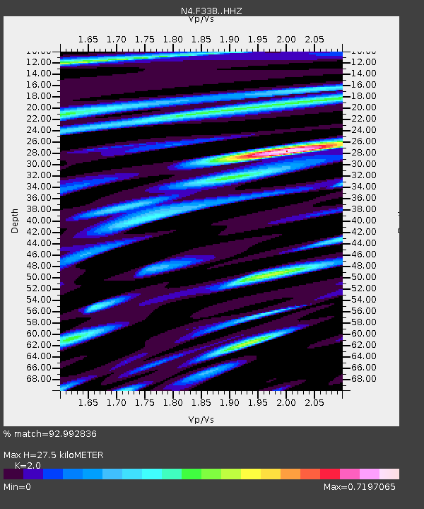
| Estimated Moho Depth: |
27.5 km |
| Estimated Crust Vp/Vs: |
2.00 |
| Assumed Crust Vp: |
6.552 km/s |
| Estimated Crust Vs: |
3.276 km/s |
| Estimated Crust Poisson's Ratio: |
0.33 |
|
| Radial Match: |
92.992836 % |
| Radial Bump: |
400 |
| Transverse Match: |
83.486336 % |
| Transverse Bump: |
400 |
| SOD ConfigId: |
13570011 |
| Insert Time: |
2019-04-30 23:50:38.407 +0000 |
| GWidth: |
2.5 |
| Max Bumps: |
400 |
| Tol: |
0.001 |
|

Signal To Noise
| Channel | StoN | STA | LTA |
| N4:F33B: :HHZ:20180824T09:12:52.339998Z | 107.16888 | 2.1206697E-5 | 1.9788114E-7 |
| N4:F33B: :HHN:20180824T09:12:52.339998Z | 214.97325 | 3.165101E-5 | 1.4723231E-7 |
| N4:F33B: :HHE:20180824T09:12:52.339998Z | 259.34448 | 2.942154E-5 | 1.134458E-7 |
| Arrivals |
| Ps | 4.4 SECOND |
| PpPs | 12 SECOND |
| PsPs/PpSs | 16 SECOND |


