You are here: Home > Network List > N4 - Central and EAstern US Network Stations List
> Station F64A Sherman, ME, USA > Earthquake Result Viewer
F64A Sherman, ME, USA - Earthquake Result Viewer
| Earthquake location: |
Peru-Brazil Border Region |
| Earthquake latitude/longitude: |
-11.0/-70.8 |
| Earthquake time(UTC): |
2018/08/24 (236) 09:04:06 GMT |
| Earthquake Depth: |
609 km |
| Earthquake Magnitude: |
7.1 Mww |
| Earthquake Catalog/Contributor: |
NEIC PDE/us |
|
| Network: |
N4 Central and EAstern US Network |
| Station: |
F64A Sherman, ME, USA |
| Lat/Lon: |
45.86 N/68.35 W |
| Elevation: |
179 m |
|
| Distance: |
56.7 deg |
| Az: |
2.063 deg |
| Baz: |
182.899 deg |
| Ray Param: |
0.061384734 |
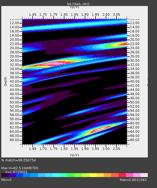
| Estimated Moho Depth: |
62.5 km |
| Estimated Crust Vp/Vs: |
1.97 |
| Assumed Crust Vp: |
6.419 km/s |
| Estimated Crust Vs: |
3.254 km/s |
| Estimated Crust Poisson's Ratio: |
0.33 |
|
| Radial Match: |
89.058754 % |
| Radial Bump: |
353 |
| Transverse Match: |
79.07877 % |
| Transverse Bump: |
400 |
| SOD ConfigId: |
13570011 |
| Insert Time: |
2019-04-30 23:50:43.514 +0000 |
| GWidth: |
2.5 |
| Max Bumps: |
400 |
| Tol: |
0.001 |
|

Signal To Noise
| Channel | StoN | STA | LTA |
| N4:F64A: :HHZ:20180824T09:12:23.049989Z | 65.84142 | 1.3471657E-5 | 2.0460763E-7 |
| N4:F64A: :HHN:20180824T09:12:23.049989Z | 30.50828 | 6.293959E-6 | 2.063033E-7 |
| N4:F64A: :HHE:20180824T09:12:23.049989Z | 12.476558 | 1.9418208E-6 | 1.5563755E-7 |
| Arrivals |
| Ps | 9.9 SECOND |
| PpPs | 28 SECOND |
| PsPs/PpSs | 38 SECOND |


