You are here: Home > Network List > N4 - Central and EAstern US Network Stations List
> Station M44A Midewin, Midewin Nat. Tallgrass Prarie, IL, USA > Earthquake Result Viewer
M44A Midewin, Midewin Nat. Tallgrass Prarie, IL, USA - Earthquake Result Viewer
| Earthquake location: |
Peru-Brazil Border Region |
| Earthquake latitude/longitude: |
-11.0/-70.8 |
| Earthquake time(UTC): |
2018/08/24 (236) 09:04:06 GMT |
| Earthquake Depth: |
609 km |
| Earthquake Magnitude: |
7.1 Mww |
| Earthquake Catalog/Contributor: |
NEIC PDE/us |
|
| Network: |
N4 Central and EAstern US Network |
| Station: |
M44A Midewin, Midewin Nat. Tallgrass Prarie, IL, USA |
| Lat/Lon: |
41.39 N/88.04 W |
| Elevation: |
207 m |
|
| Distance: |
54.5 deg |
| Az: |
344.122 deg |
| Baz: |
159.086 deg |
| Ray Param: |
0.06270931 |
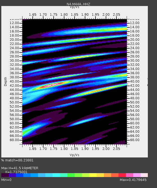
| Estimated Moho Depth: |
41.5 km |
| Estimated Crust Vp/Vs: |
1.74 |
| Assumed Crust Vp: |
6.498 km/s |
| Estimated Crust Vs: |
3.74 km/s |
| Estimated Crust Poisson's Ratio: |
0.25 |
|
| Radial Match: |
88.23881 % |
| Radial Bump: |
376 |
| Transverse Match: |
74.08416 % |
| Transverse Bump: |
400 |
| SOD ConfigId: |
13570011 |
| Insert Time: |
2019-04-30 23:51:14.385 +0000 |
| GWidth: |
2.5 |
| Max Bumps: |
400 |
| Tol: |
0.001 |
|

Signal To Noise
| Channel | StoN | STA | LTA |
| N4:M44A: :HHZ:20180824T09:12:08.260011Z | 64.14239 | 1.5923253E-5 | 2.482485E-7 |
| N4:M44A: :HHN:20180824T09:12:08.260011Z | 38.16827 | 7.081956E-6 | 1.8554564E-7 |
| N4:M44A: :HHE:20180824T09:12:08.260011Z | 30.657097 | 3.250277E-6 | 1.0602037E-7 |
| Arrivals |
| Ps | 5.0 SECOND |
| PpPs | 17 SECOND |
| PsPs/PpSs | 22 SECOND |


