You are here: Home > Network List > TA - USArray Transportable Network (new EarthScope stations) Stations List
> Station S19A Harvey Farm, Monticello, UT, USA > Earthquake Result Viewer
S19A Harvey Farm, Monticello, UT, USA - Earthquake Result Viewer
| Earthquake location: |
Kuril Islands |
| Earthquake latitude/longitude: |
45.4/151.0 |
| Earthquake time(UTC): |
2008/07/06 (188) 09:08:20 GMT |
| Earthquake Depth: |
10 km |
| Earthquake Magnitude: |
5.8 MB, 5.4 MS, 5.7 MW, 5.7 MW |
| Earthquake Catalog/Contributor: |
WHDF/NEIC |
|
| Network: |
TA USArray Transportable Network (new EarthScope stations) |
| Station: |
S19A Harvey Farm, Monticello, UT, USA |
| Lat/Lon: |
37.75 N/109.14 W |
| Elevation: |
2059 m |
|
| Distance: |
70.3 deg |
| Az: |
56.02 deg |
| Baz: |
312.511 deg |
| Ray Param: |
0.05504719 |
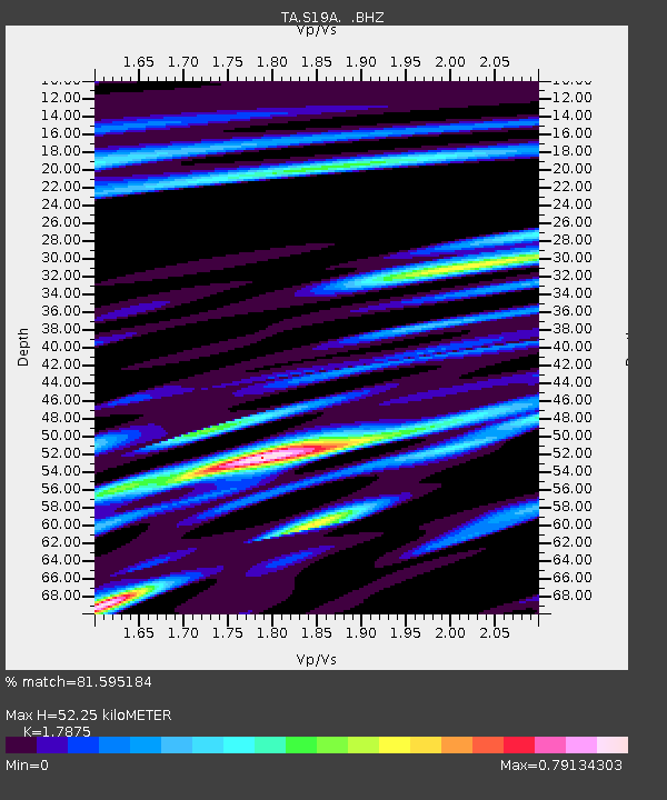
| Estimated Moho Depth: |
52.25 km |
| Estimated Crust Vp/Vs: |
1.79 |
| Assumed Crust Vp: |
6.476 km/s |
| Estimated Crust Vs: |
3.623 km/s |
| Estimated Crust Poisson's Ratio: |
0.27 |
|
| Radial Match: |
81.595184 % |
| Radial Bump: |
400 |
| Transverse Match: |
54.41801 % |
| Transverse Bump: |
400 |
| SOD ConfigId: |
2504 |
| Insert Time: |
2010-03-06 14:46:20.768 +0000 |
| GWidth: |
2.5 |
| Max Bumps: |
400 |
| Tol: |
0.001 |
|
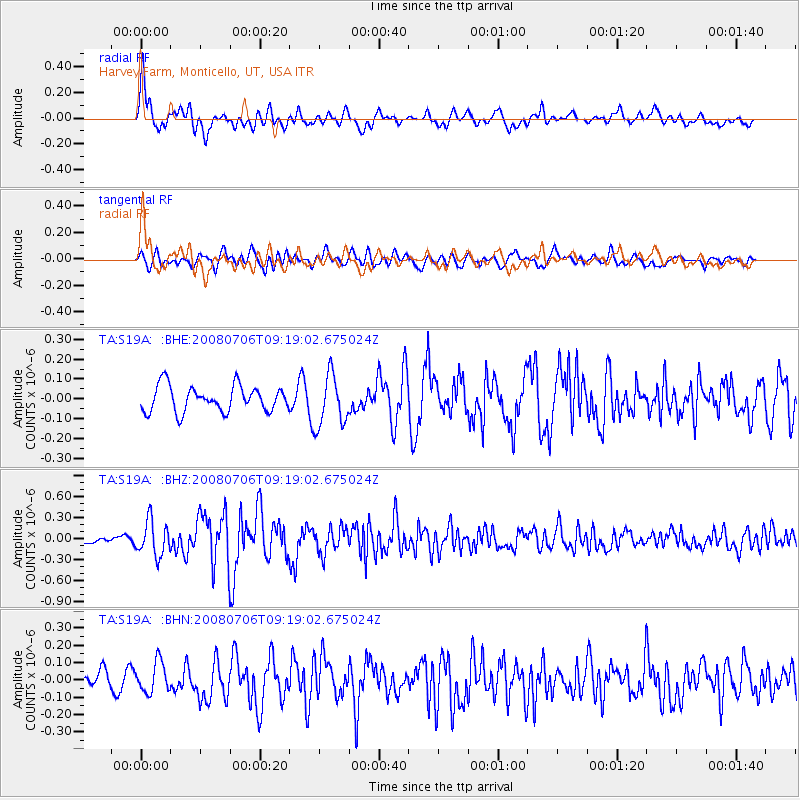
Signal To Noise
| Channel | StoN | STA | LTA |
| TA:S19A: :BHZ:20080706T09:19:02.675024Z | 3.5988653 | 2.488518E-7 | 6.91473E-8 |
| TA:S19A: :BHN:20080706T09:19:02.675024Z | 1.4316 | 8.8679194E-8 | 6.1944114E-8 |
| TA:S19A: :BHE:20080706T09:19:02.675024Z | 2.0168839 | 1.3034162E-7 | 6.462525E-8 |
| Arrivals |
| Ps | 6.6 SECOND |
| PpPs | 22 SECOND |
| PsPs/PpSs | 28 SECOND |


