You are here: Home > Network List > TA - USArray Transportable Network (new EarthScope stations) Stations List
> Station S19A Harvey Farm, Monticello, UT, USA > Earthquake Result Viewer
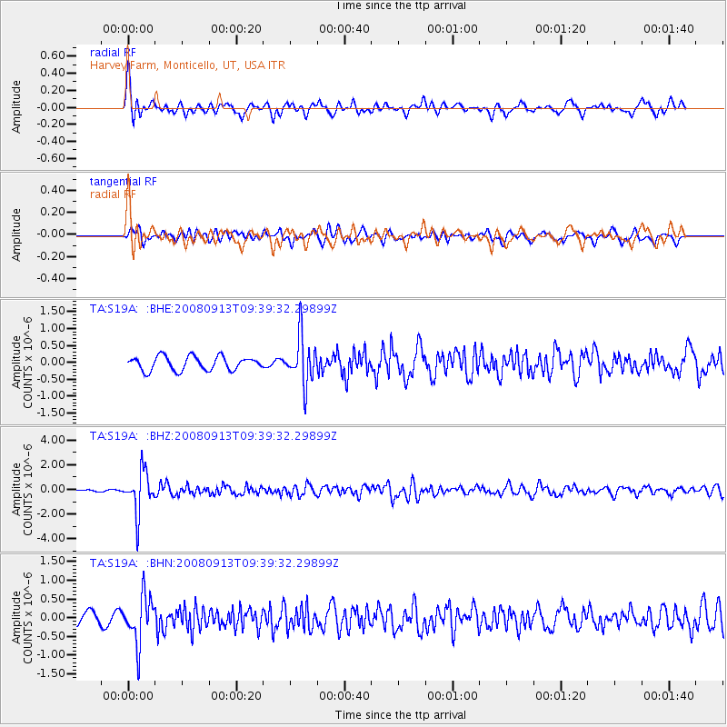
S19A Harvey Farm, Monticello, UT, USA - Earthquake Result Viewer
*The percent match for this event was below the threshold and hence no stack was calculated.
| Earthquake location: |
Colombia |
| Earthquake latitude/longitude: |
4.8/-75.5 |
| Earthquake time(UTC): |
2008/09/13 (257) 09:32:01 GMT |
| Earthquake Depth: |
133 km |
| Earthquake Magnitude: |
5.9 MB, 5.7 MW, 5.7 MW |
| Earthquake Catalog/Contributor: |
WHDF/NEIC |
|
| Network: |
TA USArray Transportable Network (new EarthScope stations) |
| Station: |
S19A Harvey Farm, Monticello, UT, USA |
| Lat/Lon: |
37.75 N/109.14 W |
| Elevation: |
2059 m |
|
| Distance: |
44.9 deg |
| Az: |
321.548 deg |
| Baz: |
128.578 deg |
| Ray Param: |
$rayparam |
*The percent match for this event was below the threshold and hence was not used in the summary stack. |
|
| Radial Match: |
68.7149 % |
| Radial Bump: |
400 |
| Transverse Match: |
50.5042 % |
| Transverse Bump: |
400 |
| SOD ConfigId: |
2560 |
| Insert Time: |
2010-03-06 14:46:25.391 +0000 |
| GWidth: |
2.5 |
| Max Bumps: |
400 |
| Tol: |
0.001 |
|
Signal To Noise
| Channel | StoN | STA | LTA |
| TA:S19A: :BHZ:20080913T09:39:32.29899Z | 15.969719 | 1.6798215E-6 | 1.05187915E-7 |
| TA:S19A: :BHN:20080913T09:39:32.29899Z | 4.2218285 | 6.3231835E-7 | 1.4977357E-7 |
| TA:S19A: :BHE:20080913T09:39:32.29899Z | 3.477248 | 7.100484E-7 | 2.0419839E-7 |
| Arrivals |
| Ps | |
| PpPs | |
| PsPs/PpSs | |


