You are here: Home > Network List > NN - Western Great Basin/Eastern Sierra Nevada Stations List
> Station WAK Walker, California w84 > Earthquake Result Viewer
WAK Walker, California w84 - Earthquake Result Viewer
| Earthquake location: |
Peru-Brazil Border Region |
| Earthquake latitude/longitude: |
-11.0/-70.8 |
| Earthquake time(UTC): |
2018/08/24 (236) 09:04:06 GMT |
| Earthquake Depth: |
609 km |
| Earthquake Magnitude: |
7.1 Mww |
| Earthquake Catalog/Contributor: |
NEIC PDE/us |
|
| Network: |
NN Western Great Basin/Eastern Sierra Nevada |
| Station: |
WAK Walker, California w84 |
| Lat/Lon: |
38.50 N/119.44 W |
| Elevation: |
1890 m |
|
| Distance: |
67.0 deg |
| Az: |
320.231 deg |
| Baz: |
126.829 deg |
| Ray Param: |
0.05503219 |
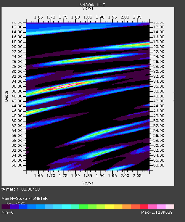
| Estimated Moho Depth: |
35.75 km |
| Estimated Crust Vp/Vs: |
1.75 |
| Assumed Crust Vp: |
6.279 km/s |
| Estimated Crust Vs: |
3.583 km/s |
| Estimated Crust Poisson's Ratio: |
0.26 |
|
| Radial Match: |
88.86458 % |
| Radial Bump: |
400 |
| Transverse Match: |
76.37372 % |
| Transverse Bump: |
400 |
| SOD ConfigId: |
13570011 |
| Insert Time: |
2019-04-30 23:52:53.656 +0000 |
| GWidth: |
2.5 |
| Max Bumps: |
400 |
| Tol: |
0.001 |
|

Signal To Noise
| Channel | StoN | STA | LTA |
| NN:WAK: :HHZ:20180824T09:13:29.42502Z | 127.496735 | 1.1146899E-5 | 8.74289E-8 |
| NN:WAK: :HHN:20180824T09:13:29.42502Z | 25.655176 | 2.019025E-6 | 7.869854E-8 |
| NN:WAK: :HHE:20180824T09:13:29.42502Z | 88.639626 | 4.36772E-6 | 4.927503E-8 |
| Arrivals |
| Ps | 4.4 SECOND |
| PpPs | 15 SECOND |
| PsPs/PpSs | 20 SECOND |


